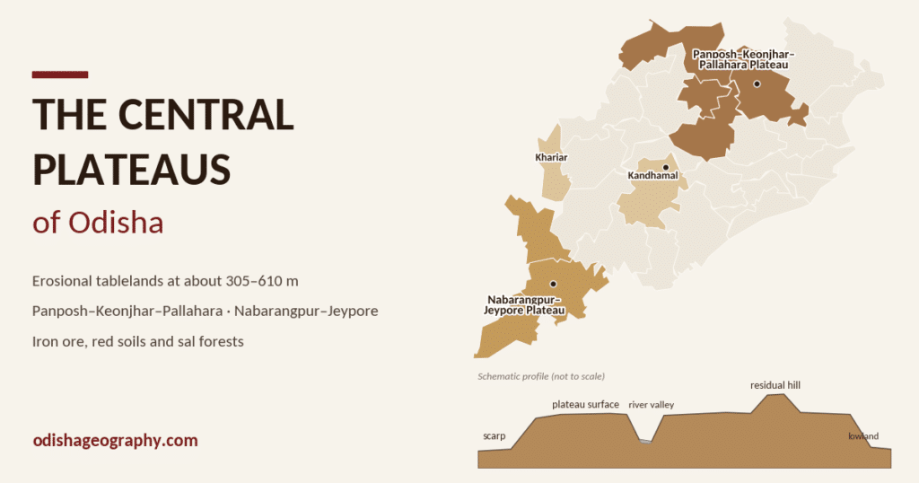
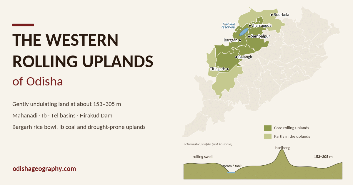
The Western Rolling Uplands are the lowest of the inland surfaces. They are gently undulating lands at about 153–305 m above sea level, lower than the plateaus (about 305–610 m) but higher than the coastal plain.
The word rolling describes the ground well. There are no sharp ranges here. Instead there are long, low swells of land separated by shallow river valleys, broken here and there by isolated rocky hills. Millions of years of erosion by the Mahanadi, Brahmani and their tributaries have worn the old plateau surfaces down into this undulating country. This region is the agricultural and industrial heartland of western Odisha. It includes the Hirakud command area, the ‘rice bowl’ of Bargarh, the coal and aluminium belt of Jharsuguda, and the drought-prone Bolangir–Titlagarh tract.
Location and extent
The uplands lie mainly in the western half of Odisha, between the northern plateaus (Sundargarh–Keonjhar) and the Eastern Ghats highlands of Kalahandi and Koraput. They extend roughly from the Chhattisgarh border in the west to the foothills around Rairakhol and Sonepur in the east.
The core of the region falls in these districts:
- Sundargarh (Rajgangpur–Rourkela area)
- Jharsuguda
- Sambalpur (the Mahanadi valley and plains around Sambalpur town)
- Bargarh
- Balangir (Bolangir–Titlagarh–Patnagarh)
- Subarnapur (Sonepur)
- Kalahandi (the lower ground around Bhawanipatna) and parts of Nuapada
The State Government’s own description also counts some smaller rolling-upland pockets outside the west, notably the Rairangpur uplands of northern Mayurbhanj and the Malkangiri uplands in the far south. These are lower, eroded surfaces that sit next to higher plateaus, just like the western uplands, even though they are geographically separate.
Origin and geology
The Western Rolling Uplands are erosional landforms. They were not built up. They are what remains after very long periods of weathering and river erosion wore down older, higher plateau surfaces. Geographers describe such a worn-down surface as a peneplain: an almost-plain with a gently rolling profile.
The rocks underneath are mostly very old:
- Precambrian granites and gneisses form the basement across most of Sambalpur, Bargarh, Balangir and Subarnapur. They weather into the red, gritty soils typical of the region.
- Eastern Ghats rocks (khondalite and charnockite) form the southern and south-eastern margins, towards Balangir, Kalahandi and Rairakhol.
- Neoproterozoic limestones and shales related to the Chhattisgarh basin occur in western Bargarh and Nuapada.
- Gondwana sedimentary rocks of the Ib River coalfield occupy a trough in Jharsuguda and Sundargarh.
Because hard and soft rocks wear away at different rates, the surface is uneven. Resistant granite or quartzite remains as isolated rocky hills (inselbergs or tors) rising above gently sloping rock benches (pediments). Patches of hard laterite cap some of the higher swells.
Relief, landforms and sub-regions
The general height of 153–305 m hides a lot of local variety. The land rises gently towards the plateau edges and drops into broad, shallow valleys along the rivers. Typical landforms include:
- Undulating interfluves: low, wide ridges between rivers, often used for upland crops and scrub forest.
- Shallow valley floors: flatter strips along streams, with deeper soils and paddy fields.
- Inselbergs and tors: isolated granite hills and boulder piles that stand out sharply from the plain.
- Laterite mounds and benches: hard, reddish caps on higher ground.
- Man-made tanks: thousands of traditional water-harvesting tanks (bandha and kata) dot the landscape, built to hold monsoon run-off on the gently sloping land.
The Orissa Annual Reference (State Government) names these sub-regions of the rolling uplands:
| Sub-region | Main districts | River basin |
|---|---|---|
| Rajgangpur uplands | Sundargarh | Koel–Sankh (upper Brahmani) |
| Jharsuguda uplands | Jharsuguda | Ib |
| Bargarh uplands | Bargarh, Sambalpur | Middle Mahanadi (Jira, Danta) |
| Bolangir–Titlagarh–Patnagarh uplands | Balangir, Subarnapur | Tel, Suktel, Ong |
| Bhawanipatna uplands | Kalahandi | Tel (upper) |
| Malkangiri uplands | Malkangiri | Sabari |
| Rairangpur uplands | Mayurbhanj | Subarnarekha |
Other accounts use a slightly different grouping, for example combining Bolangir, Bargarh and Rairakhol into one unit and adding a Rourkela upland on the upper Brahmani. In every version, the Mahanadi–Ib–Tel country of western Odisha remains the largest and most typical block.
Drainage
Almost all of the Western Rolling Uplands drain into the middle Mahanadi, with the Sundargarh section draining to the upper Brahmani. The main rivers are:
- Mahanadi: enters Odisha from Chhattisgarh and is impounded at Hirakud near Sambalpur before flowing south-east past Sonepur.
- Ib: rises in the Chhattisgarh hills and flows through Sundargarh and Jharsuguda into the Hirakud reservoir. Its valley holds the Ib coalfield.
- Tel: the largest right-bank tributary of the Mahanadi in Odisha. It drains Kalahandi, Nuapada and Balangir and joins the Mahanadi near Sonepur.
- Ong, Jira and Danta: smaller tributaries that drain the Bargarh plains.
- Suktel, Lant, Utei and Udanti: tributaries of the Tel in Balangir, Kalahandi and Nuapada.
- Sankh and Koel: these meet at Vedvyas near Rourkela to form the Brahmani.
The rivers are mostly seasonal in character. They run full during the monsoon and shrink sharply in the dry months, because the hard rock below holds little groundwater.
Hirakud Dam
Hirakud Dam on the Mahanadi, completed in 1957, is the defining feature of the region. Its main earthen and masonry dam, together with long dykes on both sides, makes it one of the longest dams in the world. The reservoir floods a large part of the old upland surface near Sambalpur and Jharsuguda. Canals from it irrigate the plains of Sambalpur, Bargarh, Subarnapur and Balangir. The dam also generates hydro-power and protects the delta downstream from floods.
Other projects serving the uplands include the Upper Indravati project, which carries Indravati water into the Tel basin of Kalahandi, and the Lower Suktel project in Balangir.
Climate
The uplands are far from the sea and have a tropical monsoon climate with strong continental extremes. They are much hotter in summer and cooler in winter than coastal Odisha.
- Summer (March–mid-June) is very hot and dry. Western Odisha towns are often among the hottest in India in April and May. Titlagarh in Balangir district is notorious: it touched 48.5 °C in April 2016. Sambalpur, Jharsuguda, Bolangir and Bhawanipatna regularly cross 44–46 °C during heat waves.
- The south-west monsoon (mid-June–September) brings most of the year’s rain. Annual rainfall is around 1,200–1,600 mm; Sambalpur averages about 1,530 mm. Rainfall decreases towards the Balangir–Nuapada belt, which lies in the rain shadow of the Eastern Ghats.
- Winter (December–February) is clear and cool, with night temperatures falling to around 10–12 °C.
The main climatic problem is unreliable rainfall. The monsoon often starts late, breaks for long spells in July–August or ends early. Combined with high summer heat and fast run-off on the sloping rocky surface, this makes the Balangir–Kalahandi–Nuapada belt one of the most drought-prone areas of India.
Soils and natural vegetation
Soils
The soils follow the rolling relief. On the same slope, the soil type often changes from the top of a swell down to the valley floor:
- Red soils (sandy to loamy, formed on granite and gneiss) cover the uplands and upper slopes. They are light and well drained but low in nitrogen, phosphorus and organic matter.
- Red and yellow soils occur on the gentler middle slopes.
- Lateritic soils occur on older, higher surfaces, especially around Sambalpur and Sundargarh.
- Black soils are found in the lower valleys and depressions of Bargarh, Balangir, Subarnapur and Kalahandi. These are heavy, moisture-retentive clays that suit cotton, pulses and rabi crops.
- Alluvial soils form narrow strips along the Mahanadi, Tel and Ib.
Local farmers have long classified their land along this slope as at (upland), mal (medium land) and bahal (lowland). Paddy is grown mostly on the lower lands.
Natural vegetation
The natural cover is tropical dry deciduous forest, with moist deciduous forest on the wetter northern and eastern edges. Sal dominates in Sambalpur and Sundargarh. Towards Balangir and Nuapada, sal gives way to mixed forest of teak, bija, asan, mahua, kendu and bamboo. Much of the open upland has been cleared for cultivation or degraded to scrub. Larger forests survive on the surrounding hills, for example Debrigarh on the Hirakud reservoir, Gandhamardan on the Balangir–Bargarh border and the Sunabeda plateau in Nuapada.
Kendu leaf (used for bidi wrappers) and mahua flowers are important forest products for local people.
Agriculture and irrigation
Farming is the main livelihood. Within the uplands, however, there is a sharp contrast between irrigated and rain-fed areas.
The Hirakud command area (Sambalpur, Bargarh and parts of Subarnapur and Balangir) is one of Odisha’s most productive farming tracts. Canal water allows two paddy crops a year, and Bargarh is widely called the ‘rice bowl of Odisha’. Paddy procurement, rice mills and agro-trade in Bargarh and Sambalpur depend on this canal system.
The rain-fed uplands (most of Balangir, Nuapada, upland Kalahandi and Sundargarh) grow a single kharif crop in most years. The main crops are:
- Paddy on the medium and low lands (mal and bahal)
- Millets (ragi, small millets) and maize on the uplands
- Pulses (arhar, green gram, black gram, horse gram) and oilseeds (groundnut, niger, mustard)
- Cotton, grown increasingly on the black soils of Kalahandi, Balangir and Nuapada; western Odisha produces most of the state’s cotton
- Vegetables around Sambalpur, Bargarh and Bolangir towns
Besides Hirakud, irrigation comes from medium projects such as Upper Indravati, Lower Suktel and Ong, from thousands of traditional tanks (kata and bandha), and increasingly from lift irrigation and borewells. Even so, a large share of the cropped area in Balangir, Nuapada and Kalahandi remains rain-fed, so harvests rise and fall with the monsoon.
Minerals and industries
Minerals
- Coal: the Ib Valley coalfield in Jharsuguda and Sundargarh is one of the largest in India and the second-largest in Odisha after Talcher. Mahanadi Coalfields Ltd operates large opencast mines at Lakhanpur, Belpahar, Lajkura and Samaleswari.
- Limestone and dolomite: found around Rajgangpur (Sundargarh) and in western Bargarh, where they feed the cement industry.
- Graphite: mined in Balangir (around Titlagarh and Patnagarh) and in Kalahandi; Odisha is one of India’s leading graphite producers.
- Fireclay, quartzite, mica and gemstones: occur in Sambalpur, Balangir and Kalahandi.
- Bauxite: found on the hilltops surrounding the uplands, for example in Kalahandi and on the Gandhamardan hills, rather than on the uplands themselves.
Industries
Cheap coal, Hirakud’s water and power, and rail links on the Howrah–Mumbai line have made the northern part of the uplands one of Odisha’s main industrial corridors:
- Aluminium: Hindalco’s smelter at Hirakud and Vedanta’s large smelter at Jharsuguda
- Steel: the Rourkela Steel Plant, on the edge of the Rajgangpur–Rourkela uplands, along with many sponge iron and ferro-alloy units around Jharsuguda and Sambalpur
- Cement: plants at Rajgangpur and Bargarh
- Thermal power: several coal-fired plants in the Ib valley and around Jharsuguda
- Agro-based industry: rice mills in Bargarh and Sambalpur, plus cotton ginning in Kalahandi and Balangir
- Handloom: the famous Sambalpuri tie-and-dye (bandha) weaving of Bargarh, Sonepur and Balangir
Industrial growth is concentrated in Jharsuguda, Sambalpur and Sundargarh. The southern uplands (Balangir, Nuapada, Kalahandi) remain mainly agricultural.
People, settlements and culture
The gentle relief has always been easier to settle than the hills around it, so the uplands have a fairly even spread of nucleated villages, usually sited on higher ground beside a tank, with paddy fields on the lower land below. Population is densest in the irrigated Hirakud command area and thinner on the dry uplands of Balangir and Nuapada. Scheduled Tribe communities (such as the Gond, Binjhal, Kisan and Oraon) and Scheduled Caste communities form a large share of the population, especially near the forested hills.
The main towns grew at river crossings, rail junctions and around mines and industries:
- Sambalpur: historic capital of the region on the Mahanadi; a university, administrative and trading city
- Rourkela: steel city and the largest urban centre of western Odisha
- Jharsuguda: rail junction and industrial town, with the Veer Surendra Sai airport
- Bargarh, Balangir, Bhawanipatna, Sonepur and Titlagarh: district headquarters and market towns
The uplands form the core of the Kosal cultural region of western Odisha. Its distinct features include the Sambalpuri (Kosli) language, the Sambalpuri ikat sarees and fabrics, Dalkhai and Rasarkeli folk dances, and the Nuakhai harvest festival, when the new rice is first offered to the goddess. Samaleswari at Sambalpur is the region’s presiding deity, and Sonepur is famous for its many temples.
Problems and development
The Western Rolling Uplands face a set of linked problems:
- Recurring drought: erratic monsoon rain, high summer heat and fast run-off cause frequent crop failure in Balangir, Nuapada and Kalahandi.
- Soil erosion and land degradation: cleared slopes on the rolling surface lose topsoil quickly, gullies form and tanks silt up.
- Groundwater scarcity: the hard granite-gneiss basement stores little water, so wells run dry in summer.
- Uneven development: industry and irrigation are concentrated in the Jharsuguda–Sambalpur–Bargarh belt, while the southern uplands lag behind on income and human-development indicators.
- Seasonal distress migration: many workers from Balangir, Nuapada and Bargarh migrate every year to brick kilns and construction sites in other states.
- Environmental pressure in the industrial belt: mining, thermal power and smelting have raised air and water pollution around the Ib valley and Jharsuguda.
Development efforts
The southern uplands fall within the KBK region (the undivided Kalahandi, Bolangir and Koraput districts), which has received special central and state funding since the late 1990s. Other measures include:
- watershed development, and renovation of traditional tanks and check dams to hold monsoon run-off
- new and extended irrigation (Lower Suktel, Upper Indravati extensions, lift irrigation and the Mega Lift schemes)
- crop diversification into millets, pulses, cotton and horticulture, including the Odisha Millets Mission
- rural employment and housing programmes to reduce distress migration
- better roads and rail links, such as the Khurda Road–Bolangir rail line, to integrate the region with the rest of the state
Key facts at a glance
| Feature | Western Rolling Uplands |
|---|---|
| Physiographic status | One of Odisha’s five landform regions |
| Height | About 153–305 m above sea level |
| Nature | Erosional, gently undulating surface (peneplain) with residual hills |
| Main rocks | Precambrian granite-gneiss; Gondwana rocks in the Ib valley; limestone in the west |
| Main rivers | Mahanadi, Ib, Tel, Ong, Jira, Suktel; Sankh–Koel (Brahmani) |
| Key project | Hirakud Dam (1957) |
| Climate | Hot summers (Titlagarh 48.5 °C in 2016), about 1,200–1,600 mm rain, drought-prone |
| Soils | Red, red-yellow, lateritic; black soils in valleys |
| Economy | Paddy (Bargarh, the ‘rice bowl’), cotton, pulses; coal, aluminium, steel, cement |
| Main towns | Sambalpur, Rourkela, Jharsuguda, Bargarh, Balangir, Bhawanipatna |
Conclusion
The Western Rolling Uplands are the quiet middle ground of Odisha’s relief: lower than the plateaus, higher than the coast, and shaped by long erosion rather than by mountain-building. The gentle surface made the region easy to settle, farm and build industry on. The Hirakud Dam, the Ib coalfield and the Bargarh paddy lands all depend on it. But the same thin red soils, hard rock and unreliable monsoon also make the southern uplands among the most drought-prone parts of India. The future of the region depends on managing water carefully, through tanks, watersheds and irrigation, and on spreading the benefits of its industrial north to the dry uplands of Balangir, Nuapada and Kalahandi.