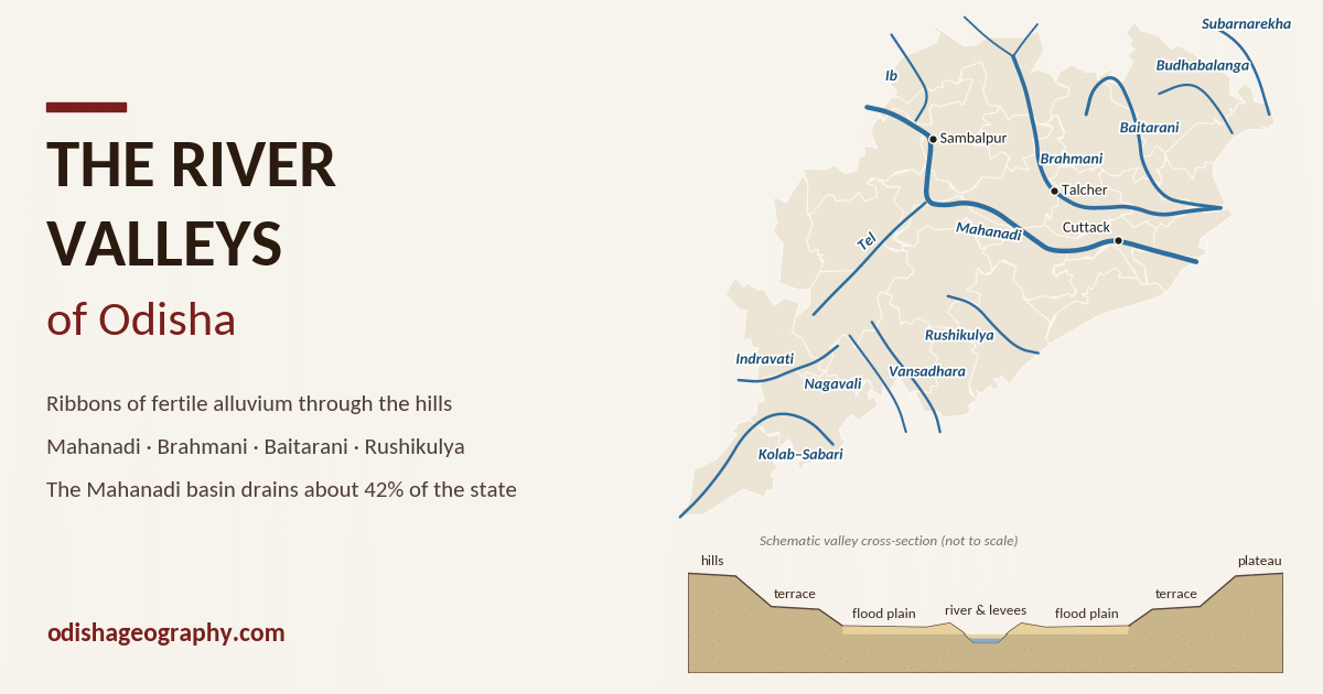
The State Government divides Odisha into five physiographic regions: the Coastal Plains, the Middle Mountainous and Highlands Region, the Central Plateaus, the Western Rolling Uplands and the River Valleys (also called the major flood plains). The river valleys differ from the other four. They are not one block of land but a set of long, narrow ribbons of low, flat ground that wind through the hills and plateaus along the state’s rivers.
These valleys are made of alluvium, the sand, silt and clay laid down by rivers in flood. They are the most fertile and most densely settled inland areas of Odisha. In the interior, almost every major town, the main railway lines and the best paddy lands follow a river valley: the Mahanadi past Sambalpur and Sonepur, the Brahmani past Talcher, the Baitarani past Anandapur, the Rushikulya past Aska. Downstream, the valleys open out and merge into the deltas of the coastal plain.
Origin and formation
Odisha’s river valleys formed in two stages.
1. Cutting the valley. Most of Odisha’s rivers are very old. They follow lines of weakness in the Precambrian rocks: faults, softer rock bands, and the troughs of the old Gondwana rift basins. The Mahanadi and Brahmani, for example, follow the Gondwana troughs of the Mahanadi and Talcher–Ib basins. Over millions of years the rivers cut broad valleys into the plateaus and hills. Where a river crosses a hard ridge, the valley narrows into a gorge, such as the Satkosia gorge of the Mahanadi.
2. Filling the floor. Every monsoon the rivers overflow and spread a fresh layer of sediment over the valley floor. Over thousands of years this has built up flat flood plains of deep alluvial soil, with sandy deposits near the channel and finer silt and clay farther away. Changes in sea level during the Quaternary period made the rivers cut down and then fill up again. This left older, higher river terraces above the present flood plain in many valleys.
The result is a typical cross-section: a wide, flat valley floor with the river winding across it, low natural embankments (levees) along the channel, one or more terraces on either side, and the hill or plateau slopes rising beyond.
Major river valleys at a glance
Odisha has eleven main river basins. Most of them drain east into the Bay of Bengal; the Indravati and Kolab (Sabari) drain west to the Godavari.

The Mahanadi alone drains about two-fifths of the state. Together with the Brahmani and Baitarani, these three rivers drain well over half of Odisha. All three end in the great combined delta of the coastal plain.
| River | Rises in | Flows into |
|---|---|---|
| Mahanadi | Sihawa hills, Dhamtari (Chhattisgarh) | Bay of Bengal near Paradip |
| Brahmani | Formed at Vedvyas (Rourkela) by the Sankh and Koel | Bay of Bengal via the Dhamra mouth |
| Baitarani | Gonasika hills, Kendujhar | Joins the Brahmani at the Dhamra mouth |
| Subarnarekha | Chota Nagpur plateau near Ranchi (Jharkhand) | Bay of Bengal near Kirtania, Baleshwar |
| Budhabalanga | Simlipal hills, Mayurbhanj | Bay of Bengal near Balaramgadi, Baleshwar |
| Rushikulya | Rushyamala hills, Kandhamal | Bay of Bengal near Ganjam town |
| Vansadhara | Thuamul Rampur hills, Kalahandi | Bay of Bengal at Kalingapatnam (Andhra Pradesh) |
| Nagavali | Thuamul Rampur hills, Kalahandi | Bay of Bengal near Srikakulam (Andhra Pradesh) |
| Indravati | Thuamul Rampur hills, Kalahandi | Godavari (westward) |
| Kolab (Sabari) | Sinkaram hills, Koraput | Godavari (westward) |
The Mahanadi valley
The Mahanadi (‘great river’) is the largest river of Odisha. It is about 851 km long, of which about 494 km flows through Odisha. It rises in the Sihawa hills of Chhattisgarh and enters Odisha near the Hirakud reservoir. Its valley crosses the state from north-west to south-east, and has four distinct stretches:
- The Sambalpur–Sonepur valley. Below Hirakud Dam the river flows through a broad valley past Sambalpur, receiving the Ib and Ong. At Sonepur (Subarnapur) the Tel, its largest tributary in Odisha, joins from the south. This is a wide, flat valley with rich alluvium and is irrigated by the Hirakud canals.
- The Boudh–Kantilo valley. The river turns east past Boudh. Here the valley floor is narrower and hemmed in by the Eastern Ghats hills to the south and the Anugul uplands to the north.
- The Satkosia gorge. Near Tikarpada the Mahanadi cuts through the Eastern Ghats in a narrow gorge about 22 km long (sat kosh, ‘seven kos’). It is flanked by forested hills of the Satkosia Tiger Reserve. This is the most dramatic stretch of the river.
- The delta head at Naraj. Below the gorge the valley widens past Kantilo and Banki. At Naraj, just above Cuttack, the river begins to divide into the Kathajodi, Kuakhai, Devi, Birupa, Chitrotpala and other branches that build the Mahanadi delta.
Cuttack itself stands on a tongue of land between the Mahanadi and the Kathajodi, at the point where the valley ends and the delta begins. Barrages at Naraj, Jobra (Cuttack) and Mundali control the flow into the delta’s irrigation canals.
The Brahmani and Baitarani valleys
Brahmani
The Brahmani is Odisha’s second-largest river basin. It is formed at Vedvyas near Rourkela, where the Sankh and the South Koel, both coming from the Chota Nagpur plateau, meet. From there it flows south and south-east for about 480 km through Odisha:
- past Rourkela and Bonaigarh in Sundargarh
- into the Rengali reservoir on the Anugul–Dhenkanal border
- through the Talcher coalfield valley, receiving the Tikira and Nandira
- past the Samal barrage and Dhenkanal, then out onto the plain near Jenapur
Below Jenapur its delta merges with the Mahanadi and Baitarani deltas. The Brahmani valley is Odisha’s most industrial river valley. It holds the Rourkela Steel Plant, the Talcher–Anugul coal, power and aluminium complex, and the Kalinganagar steel hub in Jajpur.
Baitarani
The Baitarani (about 360 km) rises in the Gonasika hills of Kendujhar. It first flows north, briefly forms the Odisha–Jharkhand boundary, then turns south-east past Champua and Anandapur. It enters the plain at Jajpur, an ancient sacred town on its banks (the river is identified with the mythical Vaitarani). It joins the Brahmani near the coast, and the combined waters reach the sea through the Dhamra estuary, next to Bhitarkanika.
The upper Baitarani valley is narrow and steep, draining the iron-ore hills of Kendujhar. This is why the river is known for sudden, fast-rising floods in its lower valley around Anandapur, Jajpur and Akhuapada.
Northern valleys: Subarnarekha and Budhabalanga
Subarnarekha
The Subarnarekha (‘streak of gold’, after the gold once panned from its sands) rises on the Chota Nagpur plateau near Ranchi. It is about 446 km long, but only its lowest 79 km or so lies in Odisha. It crosses the northern tip of Mayurbhanj and Baleshwar districts before reaching the sea near Kirtania, close to the West Bengal border. In Odisha its valley is a narrow belt of alluvium. The Subarnarekha Multipurpose Project, shared by Jharkhand, West Bengal and Odisha, supplies canal water to northern Baleshwar and Mayurbhanj.
Budhabalanga
The Budhabalanga (about 199 km in Odisha) rises in the Simlipal hills of Mayurbhanj. It flows past Baripada, the district headquarters, then crosses Baleshwar district and enters the sea near Balaramgadi, close to Chandipur. Together with its neighbour the Jambhira, it drains most of Mayurbhanj and Baleshwar. Its valley is short and steep in the upper course, so floods rise quickly after heavy rain over Simlipal. Lower down, it opens into the fertile paddy plain around Baleshwar town.
Smaller coastal streams such as the Panchpara and Kansabansa drain the strip between the Budhabalanga and the Baitarani.
Southern valleys
South of the Mahanadi, the valleys are cut into the Eastern Ghats. They are generally narrower, with steeper sides, and the flood plains are smaller than in the north.
Rushikulya
The Rushikulya (about 165 km) is the only major river that lies wholly within Odisha. It rises in the Rushyamala hills near Daringbadi (Kandhamal) and flows south-east through Ganjam district, reaching the sea near Ganjam town. Its tributaries include the Badanadi, Padma, Ghodahada and Baghua. The Aska valley is a well-watered plain known for paddy and sugarcane. The Rushikulya irrigation system, begun in the late 19th century, is one of the oldest in Odisha. The river mouth is one of the world’s great mass-nesting sites of the olive ridley turtle.
Vansadhara and Nagavali
Both rivers rise in the Thuamul Rampur–Lanjigarh hills of Kalahandi and flow south-east into Andhra Pradesh:
- The Vansadhara flows through Rayagada and Gajapati districts past Gunupur and Kashinagar, and reaches the sea at Kalingapatnam.
- The Nagavali flows past Rayagada town, where its narrow valley holds the town and its paper and alumina industries, before entering Andhra Pradesh near Srikakulam.
Westward-flowing valleys
Two river systems of the south-west drain to the Godavari, not to the Bay of Bengal directly:
- Indravati: rises in the Thuamul Rampur hills and flows west through Nabarangapur into Chhattisgarh. The Upper Indravati project dams its headwaters and diverts water to the Tel basin, irrigating Kalahandi.
- Kolab–Sabari: the Kolab rises in the Sinkaram hills of Koraput, is dammed at Upper Kolab, and continues south as the Sabari. Along Malkangiri district it forms the boundary with Chhattisgarh. Its tributary the Machkund–Sileru, with the Machkund and Balimela projects, forms the boundary with Andhra Pradesh.
The Indravati and Sabari valleys form the low, fertile corridors of the Koraput–Nabarangapur–Malkangiri plateau, home to the region’s main paddy lands and market towns.
Landforms of the river valleys
A traveller moving down any of Odisha’s main rivers sees the same family of landforms:
- Gorges and rapids: narrow, steep-sided stretches where a river cuts across a hard ridge. Examples are the Satkosia gorge of the Mahanadi and the Baitarani and Brahmani gorges near their sources. Waterfalls such as Duduma (Machkund) and Barehipani (Simlipal) mark sharp drops in the upper courses.
- Flood plains: the flat valley floors built of alluvium, flooded in big monsoon years. They are the main paddy land of each valley.
- Natural levees: slightly raised banks of coarser sediment along the channel, deposited when floodwater spills over. Villages and roads often follow them because they stay drier.
- Meanders and oxbow lakes: winding loops of the river on flat ground. Old cut-off loops survive as crescent-shaped ponds and marshes, especially in the lower Brahmani and Baitarani valleys.
- Sand bars and islands: braided channels with seasonal sandbanks are typical of the Mahanadi below Sambalpur and above Cuttack in the dry season.
- River terraces: older, higher flood plains left as steps above the present floor, often with lateritic or reddish soils.
- Deltas and distributaries: where the valleys reach the coastal plain, the rivers split into many branches. The Mahanadi–Brahmani–Baitarani rivers together build one of the largest deltas on India’s east coast.
Economic significance
Agriculture
The valleys hold the deepest and most fertile soils of inland Odisha: alluvial soils on the flood plains, with red and lateritic soils on the terraces. Paddy is the main crop. Where irrigation is available, farmers also grow rabi crops such as pulses, oilseeds, vegetables and sugarcane. River-bank (bali) lands exposed after the monsoon are used for vegetables and melons. Most of Odisha’s large irrigation projects are built across valleys: Hirakud (Mahanadi), Rengali and Samal (Brahmani), Upper Indravati, Upper Kolab, and the Rushikulya system.
Settlement
River valleys have attracted people since prehistoric times. Valley floors offer water, fertile land and easy movement. Ancient and medieval centres such as Jajpur (Baitarani), Sonepur and Boudh (Mahanadi), and Cuttack at the delta head grew on valley sites. Today the valleys are the densest inland population belts. Villages line the levees and terraces just above flood level.
Transport
Valleys provide natural routes through the hills. The Howrah–Mumbai main line follows the Ib and Brahmani valleys past Jharsuguda and Rourkela. The Talcher line runs along the Brahmani. Main roads follow the Mahanadi from Sambalpur to Cuttack. Before the railways, the Mahanadi was itself a major waterway, and boats carried salt, grain and timber between Sambalpur and Cuttack.
Industry and power
Water, coal and transport have drawn heavy industry to the valleys: steel at Rourkela and Kalinganagar, the coal, power and aluminium complex of Talcher–Anugul, and aluminium at Hirakud and Jharsuguda. Hydro-power stations stand at Hirakud, Rengali, Balimela, Upper Kolab, Upper Indravati and Machkund.
Floods and other problems
The same processes that make the valleys fertile also make them hazardous.
- Floods: heavy monsoon rain, and especially depressions from the Bay of Bengal, can raise the Mahanadi, Brahmani, Baitarani, Budhabalanga and Subarnarekha within hours. The lower valleys and the delta, where all three big rivers come close together, are among India’s most flood-prone areas. Major floods occurred in 1982, 2001, 2008, 2011 and 2020.
- Siltation: sediment eroded from the deforested and mined hills of the upper basins fills reservoirs such as Hirakud and Rengali, and raises riverbeds in the lower valley, so floods spread more easily.
- Bank erosion and shifting channels: rivers cut into their banks and change course, especially in the braided Mahanadi and the lower Baitarani. Villages and farmland are lost.
- Sand mining: heavy extraction of river sand for construction lowers riverbeds, damages bridges and embankments, and harms groundwater.
- Pollution: industrial effluent and fly ash from the Rourkela, Talcher–Anugul and Jharsuguda belts, together with urban sewage, have degraded water quality in stretches of the Brahmani and Mahanadi.
- Inter-state water disputes: Odisha shares the Mahanadi with Chhattisgarh and the Vansadhara with Andhra Pradesh. Both have led to long-running tribunal cases.
Management
The State manages these problems through multipurpose reservoirs (Hirakud, Rengali) that hold back flood peaks, embankments and barrages in the lower valleys, real-time flood forecasting by the Central Water Commission and the State, catchment treatment and afforestation in the upper basins, and stricter rules on sand mining and industrial discharge.
Conclusion
The river valleys are the smallest of Odisha’s physiographic regions by area, but they matter most to everyday life. They link the highlands to the coast, carry the water, soil and sediment that built the deltas, and hold most of the state’s inland farmland, towns, railways and industry. The Mahanadi valley alone drains about two-fifths of the state. With the Brahmani and Baitarani valleys, it forms the backbone of Odisha’s settlement and economy.
The valleys also concentrate the state’s biggest hazards: floods, siltation, bank erosion and pollution. Protecting the upper catchments, managing the reservoirs carefully and keeping the rivers clean are therefore central to Odisha’s future.