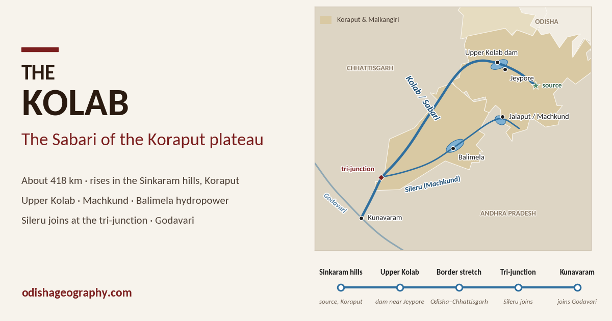
The Kolab, known downstream as the Sabari, is the main river of the Koraput plateau and one of the major tributaries of the Godavari. It is about 418 km long. It rises at about 1,370 m in the Sinkaram hills of the Eastern Ghats in Koraput district, flows across the high plateau past Jeypore, forms the boundary between Odisha and Chhattisgarh for about 200 km, and then enters Andhra Pradesh to join the Godavari at Kunavaram.
Like the Indravati, the Kolab is a west-flowing river of southern Odisha: its water reaches the sea only through the Godavari. Its basin, which also includes the Sileru (Machkund) and its famous Duduma Falls, is the heart of Odisha’s south-western hydropower system.
The Kolab–Sabari system powers the Upper Kolab, Machkund and Balimela projects, irrigates the Jeypore and Malkangiri plains, and supplies drinking water to Koraput, Jeypore, Sunabeda and Damanjodi. At the same time, its lower course is at the centre of Odisha’s concerns about submergence from Andhra Pradesh’s Polavaram project.
Source in the Sinkaram hills
The Kolab rises at about 1,370 m on the western slopes of the Eastern Ghats, in the Sinkaram hill ranges of Koraput district. This is one of the highest parts of Odisha. Nearby stands Deomali (about 1,672 m), the highest peak in the state.
The Koraput plateau, at about 900 m, is a rolling upland of ancient Precambrian rocks, including khondalites and charnockites, with laterite and bauxite capping many of the hills. Its cool climate and heavy monsoon rain feed many streams. Because the plateau tilts gently towards the west, most of these streams, the Kolab among them, drain westwards to the Godavari rather than east to the nearby Bay of Bengal.
The upper Kolab flows through a landscape of terraced paddy fields, coffee and pepper gardens, and forested hills, home mainly to Paraja, Gadaba, Kondh and other tribal communities.
Course
The Kolab–Sabari’s course of about 418 km falls into four parts.
- The Koraput plateau. From the Sinkaram hills the Kolab flows north-west across the plateau. At Bariniput, about 5 km from Jeypore, it is held back by the Upper Kolab Dam, whose reservoir spreads over about 100–114 sq km. Below the dam the river flows through the Jeypore plain, the main rice bowl of Koraput.
- The Odisha–Chhattisgarh boundary. The river then turns south-west and, as the Sabari, forms the boundary between Odisha (Koraput and Malkangiri districts) and Chhattisgarh (Bastar, Sukma) for about 200 km. This stretch falls steeply, by about 2.25 m per km on average, through forested, thinly populated country. Near the border it also receives water from the Indravati through the Jora nala.
- The tri-junction. At the southern tip of Malkangiri, where Odisha, Chhattisgarh and Andhra Pradesh meet, the Sabari is joined by its largest tributary, the Sileru, near Motu.
- Andhra Pradesh. The combined river enters Andhra Pradesh and flows south-west through the Eastern Ghats forest to join the Godavari at Kunavaram, at about 25 m above sea level. The confluence lies a short distance upstream of the Polavaram dam site.
Basin and key figures
| Measure | Figure | Source |
|---|---|---|
| Other name | Sabari (Shabari) | Wikipedia |
| Total length | about 418 km | Wikipedia |
| Odisha–Chhattisgarh boundary stretch | about 200 km | Wikipedia |
| Source elevation | about 1,370 m | Wikipedia |
| Elevation at confluence | about 25 m | Wikipedia |
| Basin area | 20,427 sq km | Wikipedia; Odisha DoWR |
| Average annual rainfall | about 1,250 mm | Wikipedia |
Districts in Odisha: Koraput and Malkangiri, with small parts of Nabarangpur. The basin also covers parts of southern Chhattisgarh (Bastar, Sukma) and northern Andhra Pradesh, and the Sileru sub-basin extends into the Visakhapatnam hills of Andhra Pradesh.
Like the Indravati, the Kolab is a sub-basin of the Godavari, but Odisha’s Water Resources Department treats it as one of the state’s eleven river basins because of its importance to the south-west of the state.
Tributaries
The Sileru (Machkund)
The Sileru is the Kolab–Sabari’s largest tributary, joining it on the left bank at the Odisha–Chhattisgarh–Andhra Pradesh tri-junction. In its upper reaches it is called the Machkund. It rises in the hills of the Andhra Pradesh–Odisha border and for much of its course forms the boundary between the two states.
The Sileru is one of the most intensively developed rivers in India for hydropower. On it stand, from upstream to downstream:
- Jalaput Dam, on the Odisha–Andhra border, feeding the Machkund power house.
- Duduma Falls, a high waterfall where the river drops off the plateau, about 48 km south of Jeypore.
- Balimela Dam in Malkangiri district.
- The Upper Sileru, Donkarayi and Lower Sileru power projects in Andhra Pradesh.
Other tributaries
- Potteru: a left-bank tributary in Malkangiri district, whose basin is irrigated by water released from Balimela under the Potteru Irrigation Project.
- Jora nala: strictly a channel rather than a tributary, it carries part of the Indravati’s flow into the Sabari near the Odisha–Chhattisgarh border.
- Numerous hill streams of the Koraput and Malkangiri plateaus.
Dams and projects
The Kolab–Sileru system is the powerhouse of southern Odisha. Its projects were built in three phases: Machkund in the 1940s–50s, Balimela in the 1960s–70s, and Upper Kolab in the 1970s–90s.
Upper Kolab Project (Odisha). Built by Odisha at Bariniput near Jeypore and now run by the Odisha Hydro Power Corporation (OHPC).
| Feature | Detail |
|---|---|
| Construction | 1976–1993 |
| Dam | Masonry gravity, 54.5 m high, 630.5 m long |
| Catchment | 1,630 sq km |
| Storage | 1,215 million m³ gross; 935 million m³ live |
| Installed capacity | 320 MW (4 × 80 MW) |
| Irrigation | about 47,985 ha (largely by lift canals) |
| Drinking water | Koraput, Jeypore, Sunabeda, Damanjodi |
Machkund (Jalaput) project. A joint project of Odisha and Andhra Pradesh on the Machkund, begun in 1946 and opened in 1955, one of the oldest hydropower schemes in India. The Jalaput Dam (60.65 m high) on the state border forms a reservoir of about 97 sq km; the water is carried past Duduma Falls to the 120 MW power house, operated by Andhra Pradesh’s power utility.
Balimela project. A dam on the Sileru at Balimela in Malkangiri, opened in 1977. It is 70 m high, its reservoir covers about 185 sq km, and its power station has an installed capacity of 510 MW. Odisha and Andhra Pradesh share the Sileru water at the dam site equally. Water released from Balimela also irrigates Malkangiri through the Potteru Irrigation Project.
Other projects. Andhra Pradesh operates the Upper Sileru (240 MW), Donkarayi (25 MW) and Lower Sileru (460 MW) stations downstream. Smaller Middle and Lower Kolab hydro schemes have been planned on the main river, as have low barrages along the Odisha–Chhattisgarh boundary stretch, and an Upper Kolab pumped-storage project has been proposed.
The hydropower system
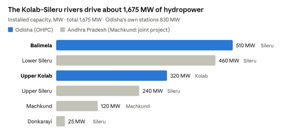
The chart shows why the Kolab basin matters so much to Odisha’s power supply. The state’s own two stations in the basin, Balimela and Upper Kolab, together make up about half of the system’s capacity. Most of the rest lies downstream on the Sileru in Andhra Pradesh, which depends on the water released from the shared reservoirs upstream.
Interstate issues
Sharing the Sileru.
The Machkund and Balimela projects were built jointly by Odisha and Andhra Pradesh. At Balimela the two states share the Sileru water available at the dam site equally. Andhra Pradesh’s share is released downstream to its Sileru power stations and, in the dry season, to irrigation in the Godavari delta. Disputes have arisen over specific proposals, such as small power units at the foot of the Balimela dam, but the basic sharing arrangement has held for decades.
The Jora nala.
Near the Odisha–Chhattisgarh border, part of the Indravati’s flow passes through the Jora nala into the Sabari. The control structure built here in agreement with Chhattisgarh decides how much water stays in the Indravati and how much reaches the Kolab–Sabari side.
Polavaram backwater.
The most serious current issue is Andhra Pradesh’s Polavaram project on the Godavari, just downstream of the Sabari confluence. Odisha fears that the backwater of the Polavaram reservoir, pushed up the Sabari and Sileru, will submerge villages and farmland in Malkangiri district, home mainly to the Koya and other tribal communities.
- Andhra Pradesh proposed about 30 km of protective embankments along the Sabari and Sileru in Odisha, but they have not been built.
- Odisha challenged the project’s environmental clearance in the Supreme Court in 2007, and the case remains unresolved.
- Public hearings on the embankments in Odisha and Chhattisgarh, required by the Environment Ministry in 2009, have not been held.
- A 2025 audit by the Comptroller and Auditor General warned that, without protective works, backwater could submerge villages in Odisha and Chhattisgarh.
Environment, culture and towns
Duduma Falls. On the Machkund, about 48 km south of Jeypore, the river plunges off the edge of the plateau in one of Odisha’s highest waterfalls. The falls are a popular tourist site, though much of the water is now diverted through the Machkund power house.
Forests and wildlife. The lower Sabari flows through dense forests on the Odisha–Chhattisgarh border and through the Papikonda hills in Andhra Pradesh, where the Godavari and its tributaries cut deep gorges.
Towns.
- Koraput, the district headquarters, on the plateau near the river’s source; known for the Sabara Srikhetra Jagannath temple and the Tribal Museum.
- Jeypore, the largest town of the basin and former capital of the Jeypore zamindari, close to the Upper Kolab dam.
- Sunabeda and Damanjodi, industrial townships (aircraft engines at Sunabeda; NALCO’s bauxite mine and alumina refinery at Damanjodi) that draw water from the Kolab system.
- Malkangiri, the district headquarters of the lower basin in Odisha.
People and culture. The Kolab–Sabari basin is one of the most tribal regions of India. The Paraja, Gadaba, Kondh, Bhumia and Didayi live on the plateau; the Koya live in the lower Malkangiri valley; and the Bonda (Remo), one of Odisha’s most distinctive particularly vulnerable tribal groups, live in the hills of Malkangiri near the Machkund. The Koraput region is also recognised as a centre of rice diversity, with a long tradition of traditional paddy varieties.
Significance
The Kolab–Sabari is the river that powers and waters Odisha’s south-west. With the Sileru it carries one of India’s oldest and most intensive chains of hydropower stations; the Upper Kolab dam irrigates the Jeypore plain and supplies the plateau’s towns and industries; and its forests and valleys are home to some of the state’s most distinctive tribal cultures. Its lower course, threatened by the Polavaram backwater, shows how decisions taken downstream in another state can shape the future of Odisha’s border districts.
Key facts at a glance
- Other name: Sabari (Shabari)
- Type: west-flowing tributary of the Godavari
- Source: Sinkaram hills, Koraput (about 1,370 m)
- Length: about 418 km (about 200 km along the Odisha–Chhattisgarh boundary)
- Basin: 20,427 sq km
- Odisha districts: Koraput, Malkangiri (small part of Nabarangpur)
- Main tributary: Sileru (Machkund), joining at the Odisha–Chhattisgarh–Andhra tri-junction
- Main projects: Upper Kolab (320 MW; about 48,000 ha), Machkund (120 MW), Balimela (510 MW)
- Confluence: Godavari at Kunavaram, Andhra Pradesh
- Key issue: Polavaram backwater submergence in Malkangiri
Notes on the figures
- No per-state split of length or basin area was available; only the 200 km boundary stretch is given.
- Upper Kolab’s capacity is given as 320 MW installed and 95 MW firm power; the two figures measure different things.
- The Middle and Lower Kolab schemes appear only in references, so their status is unclear.
- The details of Duduma Falls, the towns, the tribal communities and Koraput’s rice diversity are from general knowledge and should be checked before citing.