
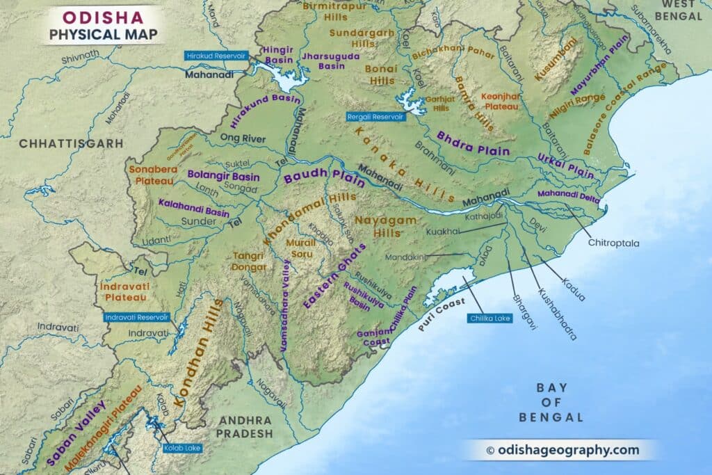
Odisha has been categorized into five primary morphological regions based on their homogeneity, continuity, and physiographical characteristics. These regions are the Odisha Coastal Plain in the east, the Middle Mountainous and Highlands Region, the Central Plateaus, the Western Rolling Uplands, and the Major River Valleys.
The Odisha Coastal Plain is situated in the eastern part of the state and is characterized by a flat and homogeneous terrain. Extending along the Bay of Bengal, this region showcases a continuous coastal plain with distinct physiographical features shaped by coastal processes. Sandy beaches, estuaries, and mangrove forests are prominent elements of this coastal plain.
The Middle Mountainous and Highlands Region occupies the central portion of Odisha. This region is marked by a series of mountains and highlands that create a heterogeneous landscape with varying elevations. The continuity of these mountainous areas contributes to the distinctive physiographical characteristics of this region.
The Central Plateaus represent another significant morphological region in Odisha. These plateaus are characterized by a relatively flat or gently undulating terrain at higher elevations. They exhibit a level topography with occasional hills and valleys, showcasing a sense of continuity across the region.
The Western Rolling Uplands cover the western and northern parts of Odisha. This region is characterized by rolling and undulating landscapes, featuring an intermix of agricultural fields, forests, and small hills. The terrain is relatively gentle, creating a visually appealing and contiguous landscape.
The Major River Valleys represent regions that encompass the wide floodplains formed by the major rivers of Odisha. These river valleys exhibit a relatively flat terrain shaped by the continuous flow of rivers. The Mahanadi, Brahmani, and Baitarani rivers have contributed significantly to the formation of these expansive floodplains, creating a distinct and continuous physiographical feature.
By dividing Odisha into these five morphological regions, based on their homogeneity, continuity, and physiographical characteristics, a comprehensive understanding of the state’s physical landscape is obtained. Each region has its own unique features and contributes to the overall diversity and dynamics of Odisha’s geography. This classification aids in studying and managing various aspects, including land use planning, resource management, and environmental conservation, based on the specific characteristics of each region.
Table of Contents
1. The Odisha Coastal Plains
The Odisha Coastal Plains, belonging to the Post-Tertiary Period, are depositional landforms that have formed relatively recently. These plains are demarcated by the 75-meter contour line, which acts as their western boundary and distinguishes them from the Middle Mountainous Region. Stretching from the border with West Bengal, specifically from the Subarnarekha River in the north, to the Rushikulya River in the south, the Odisha Coastal Plains encompass a significant coastal area.
This region is characterized by the convergence of multiple deltas formed by the major rivers of Odisha, including the Subarnarekha, Budhabalanga, Baitarani, Brahmani, Mahanadi, and Rushikulya. Hence, the coastal plain of Odisha is often referred to as the “Hexa deltaic region” or the “Gift of Six Rivers”. The coastal plain runs parallel to the Bay of Bengal, with its widest section found in the Middle Coastal Plain (Mahanadi Delta), narrower in the Northern Coastal Plain (Balasore Plain), and narrowest in the Southern Coastal Plain (Ganjam Plain).
The North Coastal Plain consists of the deltas of the Subarnarekha and Budhabalanga rivers and exhibits evidence of marine transgressions, indicating the influence of the sea on the region’s formation. The Middle Coastal Plain comprises the compound deltas of the Baitarani, Brahmani, and Mahanadi rivers and bears evidence of both past “back bays” and present-day lakes. The South Coastal Plain includes the latchstring Plain of Chilika Lake and the smaller delta of the Rushikulya River.
Although the coastal plain is often referred to as the “land of six deltas,” the rivers have not developed true deltaic characteristics in terms of their shapes. This is due to the strong offshore current that flows from Chennai to the Andhra coast and passes along the Odisha coast. In terms of the contribution of the rivers to the formation of the coastal plains, they can be rearranged in the following order: Mahanadi, Brahmani, Baitarani, Subarnarekha, Rushikulya, and Budhabalanga.
Based on their locations, the coastal plains can be further divided into the following sub-regions:
- The North Coastal Plains: This region encompasses the deltas of the Subarnarekha and Budhabalanga rivers, extending up to the Baitarani River.
- The Middle Coastal Plains: This sub-region includes the combined deltas of the Baitarani, Brahmani, and Mahanadi rivers. The Middle Coastal Plain exhibits evidence of past “back bays” and features present lakes.
- The South Coastal Plains: This sub-region consists of the entire Rushikulya plain and includes the latchstring Plain of Chilika Lake.
Configuration of the Coastal Plain
- The Salt Tract: The Salt Tract is a narrow strip of land, ranging from 4.8 to 9.6 kilometers in width, formed along the coastal plain due to the recession of the sea level caused by coastal upliftment. This tract is located adjacent to the sea and earned its name due to the presence of salt-rich soil. The high salt content in the soil renders it unsuitable for agriculture, resulting in a complete absence of farming activities. The Salt Tract is characterized by numerous brackish and slow streams, making it difficult to traverse.
- Little Sunderbans: In the Mahanadi delta, specifically off the Paradip and Dhamra coasts, a salt tract is present that is often referred to as the “Little Sunderbans.” This area is home to rich tidal forests abundant with Sundari trees, resembling the renowned Sunderbans in West Bengal. The presence of these forests adds to the natural beauty and ecological significance of the region.
- The Arable Tract: Extending beyond the Salt Tract, the Arable Tract is characterized by a relatively flat and monotonous topography. The presence of a few highlands scattered throughout the tract ensures that most of the area remains free from inundation. This tract is highly fertile, making it well-suited for agricultural activities. The Arable Tract serves as a vital agricultural zone due to its favorable soil conditions and absence of regular flooding.
- The Submontane Tract: The Submontane Tract acts as a transitional zone between the Arable Tract and the spurs of the Eastern Ghats. This area is known for its varied hill streams that have carved deep ravines along the foothills of the Eastern Ghats. The Submontane Tract is characterized by significant soil erosion and exposed blocks of laterite, giving it a barren and desolate appearance. However, certain patches of fertile land support rich vegetation. The vegetation in this tract varies, consisting of thorny shrubs and sal forests.
- The Lakes, Lagoons, and Marshes: The presence of lakes, lagoons, and marshes along the coastal plain of Odisha has been discussed in detail in the chapter dedicated to Drainage and Other Water Bodies. These water bodies play a crucial role in the ecosystem, providing habitats for various flora and fauna.
- Bays and Islands: The coast of Odisha does not have prominent bays and inlets as it is primarily a built-up or prograded coast. However, the Hukitola Bay, located off Jambu, has formed due to the development of a large complex-spit to the north of the Mahanadi estuary. As for islands, the Shortt’s Island and Wheeler Island off Maipura and Dhamra Mouths are the only two islands found off the Odisha coast. However, due to the continuous advancement of the Mahanadi delta, these islands are likely to merge with the mainland in the future.
- Natural Harbours: Paradeep is the only natural harbor in Odisha and is recognized as the deepest natural port in India. It serves as an important gateway for trade and commerce, with its hinterland extending to various states including Odisha, Jharkhand, Chhattisgarh, West Bengal, Madhya Pradesh, and Bihar. Paradeep’s strategic location and deep-water port facilities contribute to its significance in maritime trade and transport.
2. The Middle Mountainous and Highlands Region
The Middle Mountainous and Highlands Region of Odisha encompasses approximately three-fourths of the entire state and holds significant economic importance. This region is part of the Indian Peninsula and was inclined from west to east prior to the upliftment of the Eastern Ghats. The drainage lines in this region predate the formation of the Eastern Ghats and were developed as consequent streams, following the natural topography in a north-west-north (NWN) to south-east-south (SES) direction.
Primarily consisting of hills and mountains, the Eastern Ghats form the dominant feature of this region. They rise steeply and abruptly in the east, gradually sloping towards a dissected plateau in the west, spanning from the northeast to the northwest. Numerous interfluves or watersheds mark this region, while the Eastern Ghats are interrupted by various broad and narrow river valleys and flood plains. The average elevation of this region is approximately 900 meters above mean sea level, adding to its scenic beauty and diverse topography.
According to B.N. Sinha’s classification, the Middle Mountainous Region can be further divided into several second-order regions:
- The Similipal and Meghasani Mountains: These dome-shaped mountains of volcanic origin have an elevation ranging from 600 meters to 1,050 meters above mean sea level (MSL). With a nearly circular extension, they feature two prominent peaks, Similipal and Meghasani (1,147 meters). The drainage pattern in this area follows a radial pattern, giving it a distinct characteristic.
- The Mankaranacha-Malayagiri and Gandhamardan Mountains of the Baitarani and Brahmani interfluve: This group of mountains comprises three lofty peaks that extend in a north-south (NS) direction. The peaks include Malayagiri (1,170 meters) in Pala-Lahara, Mankaranacha in Banei (1,092 meters), and Gandhamardan (1,044 meters) in Kendujhar. All these mountains are part of the Eastern Ghats, whose original trend is northeast to southwest (NE to SW). However, the present north-south direction of this mountain group is a result of continuous fluvial erosion by the Baitarani and Brahmani rivers. This area is characterized by a polycyclic nature.
- Watershed between the Brahmani and the Mahanadi: The evolution of these mountains is similar in character to the previous region, but they have undergone more extensive erosion due to the continuous action of the Mahanadi and Brahmani rivers. These mountains have been reduced to a height of only 600 meters. The trend of these mountains is northwest (NW) in the northern portion and north-northwest to south-southeast (NNW to SSE) in the southern portion.
- The Common Interfluve of the Mahanadi, Rushikulya, and Vamsadhara: This watershed region is deeply eroded, with elevations ranging from 600 meters to 1,000 meters. It stretches in a north-south direction and is characterized by several peaks rising above 1,200 meters. Notable peaks in this area include Singaraju and Mahendragiri (above 1,500 meters) and Devagiri (1,360 meters).
- The Potangi and Chandragiri Mountain Ranges: These mountain ranges are the highest in Odisha, with an average height ranging from 900 to 1,350 meters. The five tallest mountains in the Eastern Ghats are found in this region, all surpassing 1,500 meters in elevation. The highest peak in Odisha, Deomali Peak, stands at an elevation of 1,672 meters and is the tallest in the entire Eastern Ghats. Other notable peaks include Galikonda (1,643 meters), Sinkaram (1,620 meters), and Turiakonda (1,598 meters). The original northeast to southwest trend of the Eastern Ghats is preserved in this section. These mountains act as a complete barrier, separating the Nagavali and Sabari basins. They are highly dissected, and terrace cultivation is practiced in the valleys, while the hilltops remain bare due to shifting cultivation practices.
3. The Central Plateaus
The plateaus in Odisha are characterized by eroded flatlands that extend along the western slopes of the Eastern Ghats. These plateaus have an elevation ranging from 305 to 610 meters and exhibit typical features of peninsular tablelands. They are relatively flat, with a uniform topography that is occasionally interrupted by deep river valleys cutting through the terrain.
In Odisha, two broad plateaus can be identified:
- The Panposh – Keonjhar – Pallahara Plateau: This plateau encompasses the Upper Baitarani catchment basin. It is named after the towns of Panposh, Keonjhar, and Pallahara, which are situated within its boundaries. The plateau is characterized by its expansive flatlands and is an important region for water catchment and drainage in the Baitarani River system. It exhibits the typical features of a plateau, including gentle slopes and a relatively level terrain.
- The Nabarangpur – Jeypore Plateau: This plateau includes the Sabari basin and is named after the towns of Nabarangpur and Jeypore. It is located in the southern part of Odisha, close to the border with Andhra Pradesh. The Nabarangpur – Jeypore Plateau features a similar topography to the Panposh – Keonjhar – Pallahara Plateau, with flat and eroded tablelands extending across the region. The plateau plays a crucial role in the drainage system of the Sabari River and surrounding areas.
Both plateaus exhibit the characteristic features of peninsular tablelands, with their flat terrain and interrupted monotony provided by the presence of deep river valleys. These plateaus contribute significantly to the overall geographical and geological diversity of Odisha.
4. The Western Rolling Uplands
The rolling uplands in Odisha are characterized by lower elevations compared to the plateaus, with heights ranging from 150 to 300 meters. These uplands have been shaped by the continuous action of rivers and exhibit fertile soil enriched with nutrients, making them naturally suitable for wetland agriculture, particularly paddy cultivation. These uplands can be found within the Koel-Sankh basin of the upper Brahmani River, the Suktel and Tel basins of the middle Mahanadi River, and the Sabari basin. The rolling uplands can be grouped into the following regions:
- The Rajgangpur-Panposh Uplands: Located in the Koel and Sankh river basins, these uplands encompass the regions of Rajgangpur and Panposh. The rivers have played a significant role in shaping the topography of these uplands, resulting in undulating terrain suitable for cultivation.
- The Jharsuguda Uplands: Situated in the Ib basin, these uplands are characterized by their rolling topography. The Jharsuguda region is known for its elevated landscape, providing favorable conditions for various agricultural activities.
- The Bargarh Uplands: Found in the Jira and Jhaun basins, the Bargarh uplands showcase a combination of undulating and rolling terrain. These uplands are known for their fertile soil and have been conducive to agriculture in the region.
- The Balangir-Titilagarh-Patnagarh Uplands: Located in the northern Tel basin, these uplands cover the areas of Balangir, Titilagarh, and Patnagarh. The region displays rolling topography with varying elevations, making it suitable for agricultural practices.
- The Bhawanipatna Uplands: Situated in the southern Tel basin, the Bhawanipatna uplands are characterized by undulating terrain. The region provides suitable conditions for agriculture and has been an important agricultural center in Odisha.
- The Malkangiri Uplands: Found in the Sabari basin, the Malkangiri uplands exhibit rolling topography. The region is known for its fertile soil and has been utilized for agricultural purposes.
These rolling uplands contribute to the agricultural productivity of Odisha, offering favorable conditions for crop cultivation and supporting the economic development of the region.
5. River Valleys
The major river valleys in Odisha exhibit an undulating topography, characterized by variations in elevation and landforms. These valleys are closely associated with three prominent rivers: the Brahmani, the Mahanadi, and the Vamsadhara. Each river valley has its own unique characteristics, influenced by the geological processes and natural forces shaping the region.
- The Valley of the Mahanadi: The Mahanadi River, one of the largest rivers in Odisha, carves out a distinct valley as it flows through the state. The valley of the Mahanadi is marked by a narrow and deep channel in its upper reaches, where the river cuts through the hilly terrain of the Eastern Ghats. As the river progresses downstream, the valley gradually widens, creating a broader floodplain in the middle reaches. Finally, the Mahanadi River reaches its widest point as it enters the plains of Odisha, where it forms a vast deltaic region and eventually discharges into the Bay of Bengal.
- The Valley of the Brahmani: The Brahmani River, another significant river in Odisha, has its own distinct valley. Similar to the Mahanadi Valley, the Brahmani Valley exhibits a narrow and deep channel in its upper reaches, where the river flows through the rugged terrain of the Eastern Ghats. As the river continues its course, the valley becomes slightly wider in the middle reaches, accommodating the flow of water from various tributaries. In the lower reaches, near the coast, the Brahmani River enters the plains and forms a broader floodplain, contributing to the formation of the coastal plains of Odisha.
- The Valley of the Vamsadhara: The Vamsadhara River forms yet another significant valley in Odisha. This river valley displays similar characteristics to the Mahanadi and Brahmani Valleys. In its upper reaches, the Vamsadhara River cuts through the hilly terrain, creating a narrow and deep valley. As it progresses downstream, the valley gradually widens, forming a broader floodplain in the middle reaches. Finally, the river enters the plains of Odisha, where it contributes to the formation of the coastal plains and ultimately joins the Bay of Bengal.
These river valleys play a crucial role in shaping the landscape of Odisha. They provide fertile soil, water resources, and favorable conditions for agriculture and human settlements. The valleys also serve as important transportation routes, facilitating trade and commerce within the region. The diverse topography and landforms found within these valleys contribute to the ecological richness and economic development of Odisha.
Conclusion
The physiography of Odisha holds significant importance due to its influence on various aspects of the state’s environment, economy, and culture. Here are some key reasons highlighting the importance of Odisha’s physiography:
- Natural Resources: The diverse physiographic features of Odisha contribute to the abundance of natural resources found in the state. The coastal plains provide fertile soil for agriculture, while the river valleys offer water resources for irrigation and hydroelectric power generation. The plateaus and uplands harbor mineral deposits such as iron ore, coal, bauxite, and manganese, which play a crucial role in the state’s mining industry.
- Agriculture and Livelihood: The physiography of Odisha influences the suitability of different areas for agricultural practices. The coastal plains are known for their fertile soil and are extensively utilized for paddy cultivation, making Odisha one of the leading rice-producing states in India. The plateaus and uplands also support agriculture, with crops like pulses, oilseeds, vegetables, and fruits being cultivated in these regions. The varied physiographic features provide diverse livelihood opportunities for farmers and agricultural communities.
- Biodiversity and Conservation: Odisha’s physiography encompasses diverse ecosystems, including forests, wetlands, mangroves, and coastal areas. These ecosystems support a rich biodiversity with numerous plant and animal species, including several endangered and endemic ones. The forests of Odisha are home to wildlife sanctuaries and national parks, contributing to the conservation of flora and fauna. The preservation of these ecosystems is crucial for maintaining ecological balance, supporting wildlife conservation, and promoting ecotourism.
- Water Resources: The physiographic features of Odisha, such as river valleys and lakes, provide abundant water resources. Rivers like the Mahanadi, Brahmani, and Vamsadhara are major sources of water for irrigation, drinking, and industrial purposes. The Chilika Lake, a brackish water lagoon, is not only a significant water body but also a Ramsar site and a haven for migratory birds. Proper management and conservation of these water resources are essential for sustaining agriculture, fisheries, and overall ecological balance.
- Cultural and Tourism Significance: The diverse physiography of Odisha contributes to its cultural heritage and tourism potential. The state is known for its ancient temples, historical sites, and cultural traditions. The Eastern Ghats, with their scenic beauty, offer opportunities for adventure tourism, trekking, and wildlife exploration. The coastal areas attract tourists with their beaches, fishing villages, and unique cultural practices. The exploration of Odisha’s physiography enriches the understanding of its cultural diversity and heritage.
In conclusion, the physiography of Odisha plays a vital role in shaping the state’s environment, economy, and cultural identity. The diverse landscapes, natural resources, and ecological systems contribute to agriculture, biodiversity conservation, water management, and tourism. Understanding and managing the varied physiographic features are essential for sustainable development and the overall well-being of the state and its people.