
|
odishageography.com |
Physiography
The Middle Mountainous and Highlands Region of Odisha

Odisha’s relief is commonly divided into five morphological regions: the Coastal Plains, the Middle Mountainous and Highlands Region, the Central Plateaus, the Western Rolling Uplands and the Major Flood Plains. Of these, the Middle Mountainous and Highlands Region is by far the largest, covering roughly three-fourths of the state. It forms the rugged interior that separates the low coastal plain in the east from the plateaus and rolling uplands of the west.
The backbone of the region is the Eastern Ghats, which rise steeply from the coastal plain and slope gently westward into a dissected plateau with an average height of about 900 m. In the north, the region merges with the hills of the Northern Plateau (the Garhjat hills of Keonjhar, Mayurbhanj, Sundargarh and Angul). Broad and narrow river valleys break the highlands into many separate blocks, ridges and isolated peaks.
Table of Contents
Extent
The region spreads, wholly or partly, across a large part of the state, including:
- South and south-west: Koraput, Malkangiri, Nabarangpur, Rayagada, Gajapati, Kandhamal, Kalahandi (east) and western Ganjam.
- Centre: Boudh, Nayagarh, Angul, Dhenkanal, Deogarh and parts of Sambalpur.
- North: Keonjhar, Mayurbhanj, Sundargarh (east) and the hill tracts of Balasore (Nilagiri).
It holds Odisha’s highest peaks — including Deomali (1,672 m) in Koraput, the highest point of the entire Eastern Ghats — its densest forests, the sources of most of its rivers, its richest mineral deposits and most of its tribal population.
Geology and Origin
Rocks
- Eastern Ghats Granulite Belt — The southern and central highlands are made of very old, highly metamorphosed rocks: khondalite (named after the Khond hills of Odisha), charnockite, leptynite, migmatite and granite gneiss, with anorthosite and alkaline intrusions. These rocks were formed and metamorphosed in the Proterozoic, mainly about 1.0 billion years ago.
- Singhbhum (North Odisha) Craton — The northern hills of Keonjhar, Mayurbhanj and Sundargarh are carved from Archaean granites, gneisses and the Iron Ore Group (banded iron formation, shales and volcanics), more than 3 billion years old. The near-circular Similipal massif is built of Proterozoic volcanic and sedimentary rocks.
- Laterite and bauxite cap many high plateaus of the Eastern Ghats (Panchpatmali, Baphlimali, Niyamgiri), formed by deep tropical weathering of khondalite.
How the highlands formed
- Ancient mountain building — The Eastern Ghats were first raised as a mountain belt when the Indian craton collided with the East Antarctic crust in the Proterozoic.
- Long erosion — Over hundreds of millions of years they were worn down to low, rolling surfaces.
- Rifting and uplift — When India separated from Antarctica in the Cretaceous, the eastern margin was faulted and the land behind it uplifted and tilted. Later Tertiary uplift raised the old erosion surfaces to their present heights of 600–1,400 m, so the Eastern Ghats today are a dissected, block-faulted plateau rather than a young fold mountain range.
- Polycyclic landscape — Repeated uplift and erosion left several planation surfaces at different levels (about 900–1,000 m on the Koraput plateau, about 600 m on the Brahmani–Mahanadi watershed), separated by steep scarps.
Antecedent rivers
The main rivers are older than the latest uplift. Before it, the land sloped from west to east and rivers flowed down it as consequent streams. As the hills rose slowly, the Mahanadi, Brahmani and Baitarani kept cutting down through them, maintaining their courses. This is why they cross the ranges in deep gorges such as the Satkosia Gorge of the Mahanadi and the narrow valleys of the Brahmani near Rengali.
Sub-Regions of the Highlands
Following the scheme of geographer B.N. Sinha, the region is divided into five second-order sub-regions, from north to south.
1. Similipal and Meghasini Mountains (Mayurbhanj)
- A near-circular, dome-like massif about 600–1,050 m high, rising abruptly from the surrounding plains.
- Built of Proterozoic volcanic rocks and quartzites, it has a clear radial drainage pattern: the Budhabalanga, Khairi, Palpala, Salandi and other streams flow outward in all directions.
- Meghasini (about 1,166 m) is its highest point; Barehipani and Joranda waterfalls plunge from its edges.
- The massif is the core of the Similipal Tiger Reserve and Biosphere Reserve.
2. Mankarnacha–Malayagiri–Gandhamardan Mountains (Baitarani–Brahmani interfluve)
- Three high peaks aligned roughly north–south: Malayagiri (about 1,187 m, Pallahara, Angul), Mankarnacha (Bonai, Sundargarh) and Gandhamardan (Keonjhar).
- River erosion has turned the original north-east to south-west trend of the hills; the landscape is polycyclic, with several erosion levels.
- This is the heart of Odisha’s iron-ore country: the Bonai–Keonjhar hills of Joda, Barbil and Koira.
3. Brahmani–Mahanadi Watershed (Angul, Dhenkanal, Deogarh, Sambalpur)
- Similar in origin but more deeply eroded, worn down to about 600 m.
- Trends north-west in the north and north-north-west to south-south-east in the south.
- Includes the forested hills around Rengali, Satkosia, Kapilash and the Debrigarh hills on the Hirakud reservoir.
4. Mahanadi–Rushikulya–Vamsadhara Interfluve (Kandhamal, Ganjam, Gajapati, Rayagada)
- A deeply eroded watershed, about 600–1,000 m high, running roughly north–south.
- Contains peaks above 1,200 m such as Mahendragiri (about 1,501 m), close to the coast in Gajapati, and Devagiri (about 1,360 m).
- The Kandhamal highlands around Phulbani and Daringbadi (“the Kashmir of Odisha”) are cool plateaus where winter temperatures can fall close to freezing.
5. Pottangi and Chandragiri Ranges (Koraput)
- The highest ranges in Odisha, averaging about 900–1,350 m, with several peaks above 1,500 m.
- Deomali (about 1,672 m), near Pottangi, is the highest point in Odisha and in the whole Eastern Ghats; other high summits include Galikonda, Sinkaram and Turiakonda.
- They retain the original north-east to south-west trend of the Ghats and form the divide between the Nagavali and Sabari (Kolab) basins.
- The Koraput plateau (Jeypore plateau) at about 900 m slopes westward towards the Indravati and Sabari valleys; valleys are terraced for paddy and hilltops are often bare from shifting cultivation.
Other notable highland features
- Niyamgiri hills (Rayagada–Kalahandi) — sacred to the Dongria Kondh; source of the Vamsadhara and tributaries of the Nagavali.
- Gandhamardan hills (Bargarh–Balangir) — renowned for medicinal plants; Nrusinghanath and Harishankar temples lie at their foot. (Distinct from the Gandhamardan peak in Keonjhar.)
- Bauxite plateaus — Panchpatmali, Baphlimali, Sijimali and Kodingamali in Koraput, Rayagada and Kalahandi.
Highest Peaks
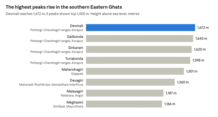
Heights fall from south to north: the Koraput ranges carry all four peaks above 1,550 m, while the northern hills of Angul, Keonjhar and Mayurbhanj stay mostly below about 1,200 m.
Drainage, Valleys and Waterfalls
The highlands are Odisha’s great water tower: almost all of the state’s rivers rise or gather their tributaries here.
Rivers rising in the highlands
| Drains towards | Rivers |
|---|---|
| Bay of Bengal directly | Budhabalanga and Baitarani (Similipal–Keonjhar hills), Rushikulya (Daringbadi–Kandhamal hills), Vamsadhara (Thuamul Rampur–Niyamgiri), Bahuda |
| Mahanadi system | Tel, Udanti, Ong, Jonk and other western tributaries; Salki and Bagh from Kandhamal |
| Brahmani system | Sankh and South Koel (from Jharkhand), Tikira, Nandira |
| Godavari system (west) | Indravati and Sabari (Kolab) from the Koraput plateau |
| Andhra coast | Nagavali (Langulya) and Machkund |
Drainage patterns
- Radial — from the Similipal dome in Mayurbhanj.
- Trellis and rectangular — along joints and faults in the Eastern Ghats and the Iron Ore ranges.
- Dendritic — on the more uniform granite gneiss plateaus of the west and centre.
- Antecedent gorges — where major rivers cut across rising ranges (Satkosia on the Mahanadi).
Gorges and valleys
- Satkosia Gorge — the Mahanadi cuts a gorge about 22 km long through the Eastern Ghats between Tikarpada and Badamul (Angul–Nayagarh–Boudh).
- Duduma gorge — the Machkund falls into a deep gorge on the Odisha–Andhra border.
- Broad structural valleys such as the Brahmani valley (Talcher), the Ib valley and the Tel valley separate the hill blocks and hold coalfields, farms and towns.
Major waterfalls
| Waterfall | River | District |
|---|---|---|
| Barehipani | Budhabalanga | Mayurbhanj (Similipal) |
| Joranda | Salandi tributary | Mayurbhanj (Similipal) |
| Duduma | Machkund | Koraput |
| Khandadhar | Korapani nala | Sundargarh and Keonjhar (two falls of this name) |
| Sanaghagara and Badaghagara | Machha Kandana | Keonjhar |
| Phurlijharan | Hill stream | Kalahandi |
| Bagra | Indravati tributary | Koraput |
| Pradhanpat | Hill stream | Deogarh |
Hydro-power and reservoirs
The steep falls and high rainfall make the highlands Odisha’s source of hydro-electricity: Machkund, Upper Kolab, Balimela, Upper Indravati, Rengali and Hirakud are all located in or at the edge of the region.
Climate, Soils, Forests and Wildlife
Climate
- Tropical monsoon climate modified by altitude. The highlands are cooler than the plains: summers are milder and winter nights cold, especially on the Koraput plateau, in Kandhamal (Daringbadi, Phulbani) and on the Similipal massif, where frost occasionally forms.
- Rainfall is generally 1,400–1,600 mm, rising above 1,600 mm on the windward slopes of Koraput, Malkangiri, Similipal and parts of Keonjhar and Sundargarh. The leeward western edges (towards Kalahandi and Balangir) are drier.
- Most rain falls from June to September; south-western highlands also receive some rain in October from retreating monsoon depressions.
Soils
- Red and yellow soils on the gneiss and granite uplands — the most widespread.
- Lateritic soils and laterite cappings on high plateaus.
- Mixed red and black soils in the western valleys.
- Forest and hill soils — thin, stony and easily eroded on slopes.
- Alluvial valley soils — narrow strips along rivers.
Forests
The region holds most of Odisha’s forest cover. The main types are:
- Tropical moist deciduous forest with sal (Shorea robusta) — Similipal, Keonjhar, Sundargarh, Kandhamal, Koraput.
- Tropical dry deciduous forest — the western and central hills, with teak, bija, asan, sidha, kendu and bamboo.
- Semi-evergreen patches in moist valleys of Similipal, Mahendragiri and Koraput.
- Hill savanna and grassy slopes on degraded hilltops where shifting cultivation is practised.
Minor forest produce — kendu leaf, sal seed, mahua flowers, bamboo, lac, tamarind, honey and medicinal plants — is vital to the livelihood of forest communities.
Wildlife and protected areas
The highlands contain most of Odisha’s protected areas: Similipal National Park and Tiger Reserve, Satkosia Tiger Reserve, Debrigarh Tiger Reserve, Kotgarh, Lakhari Valley, Karlapat, Sunabeda, Hadgarh, Kuldiha, Baisipalli and Kapilash sanctuaries. They support tigers, leopards, elephants, gaur, sambar, sloth bears, giant squirrels and rich bird and plant life.
People and Economy
Tribal homeland
The highlands are the heartland of Odisha’s Scheduled Tribes, who form 22.85% of the state’s population (Census 2011). Most of the state’s Fifth Schedule Areas lie here. Major communities include:
| Area | Main tribes |
|---|---|
| Koraput, Rayagada, Malkangiri, Nabarangpur | Kondh, Paraja, Gadaba, Bhumia, Koya, Bonda (PVTG), Didayi (PVTG) |
| Kandhamal, Kalahandi, Rayagada (Niyamgiri) | Kondh, Dongria Kondh and Kutia Kondh (PVTGs) |
| Gajapati, Ganjam hills | Lanjia Saora (PVTG), Saora |
| Keonjhar, Mayurbhanj, Sundargarh | Santal, Ho, Munda, Oraon, Bhuyan, Juang and Paudi Bhuyan (PVTGs), Kolha |
Settlements are mostly small, dispersed or hamleted villages on hill slopes and valley floors, closely tied to forests and streams.
Agriculture
- Terraced paddy in valleys and on lower slopes, especially in Koraput and Kandhamal.
- Shifting cultivation (podu or bagada) on hill slopes, still practised by some communities.
- Millets (ragi, suan, kodo), pulses (arhar), niger and oilseeds on uplands.
- Plantation and horticulture — coffee and pepper in the Koraput hills, turmeric and ginger in Kandhamal (Kandhamal Haladi has a GI tag), cashew, mango and vegetables.
- Koraput is recognised by the FAO as a Globally Important Agricultural Heritage System (GIAHS) for its traditional paddy and millet diversity.
Minerals and industry
The region is Odisha’s mineral treasure-house:
| Mineral | Main areas |
|---|---|
| Iron ore | Joda, Barbil, Koira, Bonai (Keonjhar–Sundargarh) |
| Manganese | Joda–Koira (Keonjhar–Sundargarh), Koraput–Rayagada belt |
| Bauxite | Panchpatmali (Koraput), Baphlimali, Sijimali, Kodingamali (Rayagada–Kalahandi) |
| Chromite | Sukinda valley, at the edge of the northern hills (Jajpur) |
| Coal | Talcher and Ib Valley coalfields in the valleys between the hill blocks |
| Graphite, gemstones | Balangir, Kalahandi, Koraput |
Industrial towns such as Rourkela, Barbil, Joda, Damanjodi (NALCO alumina refinery), Sunabeda (HAL), Rayagada (paper) and Lanjigarh (alumina) have grown around these resources, linked by railways such as the Koraput–Rayagada and Kirandul–Visakhapatnam lines.
Tourism
Hill stations and nature destinations include Koraput, Daringbadi, Similipal, Mahendragiri, Satkosia, Duduma, Deomali and Khandadhar, along with the colourful tribal weekly markets (haats) of Koraput and Rayagada.
Problems and Development
Key problems
- Soil erosion and land degradation — Steep slopes, heavy rain and the shortening cycle of shifting cultivation strip topsoil and silt up rivers and reservoirs.
- Deforestation — Forests are lost to shifting cultivation, mining, roads, reservoirs and illegal felling.
- Mining impacts — Opencast iron, manganese and bauxite mining causes dust, water pollution, loss of forest and grazing land, and the displacement of tribal villages; the Niyamgiri case (2013), in which Dongria Kondh gram sabhas rejected bauxite mining, became a landmark for forest rights.
- Poverty and remoteness — Many highland districts, particularly the undivided KBK region (Koraput–Balangir–Kalahandi), have high multidimensional poverty, low literacy and poor health indicators.
- Poor connectivity — Rugged terrain makes roads, railways and services costly; many hamlets were long cut off in the monsoon.
- Human–wildlife conflict, particularly with elephants in the northern and central hills.
- Left-wing extremism in the past affected parts of Malkangiri, Koraput and Kandhamal, slowing development.
Development initiatives
- Forest Rights Act (2006) titles, community forest rights and Joint Forest Management.
- Watershed development and soil-conservation projects on degraded slopes; the Odisha Millets Mission to revive traditional crops.
- Special area programmes for the KBK districts (RLTAP), the Aspirational Districts programme and PVTG development agencies.
- New railway lines (e.g., Jeypore–Malkangiri, Khurda–Balangir) and the Gurupriya bridge (2018), which connected the cut-off area of Malkangiri.
- District Mineral Foundation funds for mining-affected areas.
- Eco-tourism run by local communities in Similipal, Satkosia, Daringbadi and Koraput.
Conclusion
The Middle Mountainous and Highlands Region is the backbone of Odisha. Built of some of the oldest rocks in India and shaped by repeated uplift and erosion, its Eastern Ghats ranges, northern hills and high plateaus cover about three-fourths of the state. They give Odisha its rivers and hydro-power, its forests and wildlife, its mineral wealth, and the homeland of its many tribal communities. The challenge is to share the benefits of minerals and water with the people of the hills while protecting the forests, soils and cultures that make the region unique.
Quick Facts
| Item | Fact |
|---|---|
| Share of Odisha | About three-fourths of the state |
| Backbone | Eastern Ghats, with the Northern Plateau hills in the north |
| Average height | About 900 m |
| Highest peak | Deomali, about 1,672 m (Koraput) — highest in the Eastern Ghats |
| Other high peaks | Mahendragiri (about 1,501 m), Malayagiri (about 1,187 m), Meghasini (about 1,166 m) |
| Main rocks | Khondalite, charnockite, granite gneiss; Iron Ore Group in the north |
| Classic antecedent gorge | Satkosia Gorge of the Mahanadi |
| Key waterfalls | Barehipani, Joranda, Duduma, Khandadhar |
| Main minerals | Iron ore, manganese, bauxite, chromite, coal |
| Hill stations | Koraput, Daringbadi (“Kashmir of Odisha”) |
| Sub-regions (B.N. Sinha) | Similipal–Meghasini; Mankarnacha–Malayagiri–Gandhamardan; Brahmani–Mahanadi watershed; Mahanadi–Rushikulya–Vamsadhara interfluve; Pottangi–Chandragiri ranges |
Sources
- Physiography of Odisha — odishageography.com
- Geography of Odisha — Wikipedia
- Geology and Mineral Resources of Orissa — Directorate of Geology, Government of Odisha
- Sinha, B.N., Geography of Orissa, National Book Trust, New Delhi.
- Census of India 2011, Primary Census Abstract (Scheduled Tribes).
© Odisha Geography · Generated on November 8, 2026