
|
odishageography.com |
Human Settlements in Odisha
A human settlement is any form of human habitation — from a single hamlet in a forest clearing to a large metropolitan city — together with the houses, streets, fields and services that support it. The size, form and distribution of settlements reflect the physical environment (relief, rivers, soils, rainfall), the economy, history and culture of a region. In Odisha, the contrast between the densely settled deltaic coast and the sparsely populated hill and plateau country of the interior is written clearly into its settlement map.
Table of Contents
Odisha remains one of the least urbanised states in India. According to the Census of India 2011:
| Item | Odisha |
|---|---|
| Total population | 4,19,74,218 |
| Rural population | 3,49,70,562 (83.32%) |
| Urban population | 70,03,656 (16.68%) |
| Villages | 51,313 (47,539 inhabited, 3,774 uninhabited) |
| Towns | 223 (107 statutory towns + 116 census towns) |
| Households | about 96.4 lakh |
| Population density | 270 persons per sq km |
Odisha’s urban share of 16.68% is barely half the national figure of 31.16%, placing it among the bottom few states. Five out of six Odias still live in villages, and agriculture, forests and fisheries remain the base of most settlements. At the same time, urbanisation is accelerating: the number of towns rose from 138 in 2001 to 223 in 2011, Bhubaneswar has become one of eastern India’s fastest-growing cities, and the state notified dozens of new urban local bodies in 2025. The next Census (2027) is expected to show a marked rise in urban population.
Rural Settlements
Odisha’s 51,313 villages are spread unevenly. They are largest and closest together on the fertile, irrigated Mahanadi–Brahmani–Baitarani delta and smallest and most scattered in the forested hills of the Eastern Ghats and the Northern Plateau. The average village in Odisha has fewer than 750 people, much smaller than villages in the Gangetic plains, and a large share of villages have fewer than 500 people — especially in the tribal districts of Kandhamal, Koraput, Rayagada, Malkangiri and Mayurbhanj.
Factors influencing rural settlements
- Relief and drainage — flat, well-drained deltaic land and river levees attract large villages; hills and steep slopes allow only small hamlets.
- Water supply — villages cluster near rivers, tanks (bandha), springs and dug wells; in western Odisha, old water tanks (kata and bandha) are focal points of village life.
- Flood and cyclone risk — coastal villages are built on raised natural levees, sand ridges and old beach ridges to escape floods and storm surges.
- Agriculture and soils — alluvial soils of the coast support dense paddy villages; laterite and red soils of the uplands support thinner populations.
- Social structure — caste-based hamlets (sahi or pada) are a distinctive feature: a village is often divided into separate wards for different caste groups, with Scheduled Caste hamlets often on the edges.
- Forests and tribes — forest-dwelling communities live in small, scattered hamlets close to their shifting cultivation (podu) plots.
Types of rural settlements
| Type | Description | Where in Odisha |
|---|---|---|
| Compact / clustered | Houses packed closely around a core (temple, tank, market); fields lie outside | Coastal delta — Cuttack, Jagatsinghpur, Kendrapara, Puri, Jajpur, Balasore, Bhadrak; Hirakud command (Bargarh, Sambalpur) |
| Semi-compact | A main cluster with a few outlying houses | River valleys and plateau margins — Dhenkanal, Angul, Nayagarh, Ganjam |
| Hamleted | One revenue village broken into several sahi, pada or tola, separated by fields or social divisions | Western and northern Odisha — Balangir, Kalahandi, Keonjhar, Mayurbhanj |
| Dispersed / scattered | Isolated homesteads or tiny hamlets spread over hill slopes and forests | Eastern Ghats — Kandhamal, Koraput, Rayagada, Gajapati, Malkangiri; Similipal hills |
Patterns (shapes) of rural settlements
- Linear — along river levees, canal banks, roads and coastal sand ridges (common in the delta and along the Chilika and coastal roads).
- Rectangular / street — two rows of houses facing a broad central street; typical of Odia caste villages and of Puri’s Bada Danda at the urban scale.
- Circular — around a tank or temple.
- Fishermen’s villages — elongated settlements on beach ridges and lagoon shores (e.g., along Chilika and the Ganjam coast), with boat landing places.
Traditional rural house types
Coastal houses are typically mud-walled with thatched or tiled roofs, raised on a plinth and arranged around a courtyard, while western Odisha has mud houses with sloping tiled roofs. Since the 1999 super cyclone, and through housing schemes such as Indira Awaas Yojana, Biju Pucca Ghar Yojana and PMAY-Gramin, thousands of kutcha houses have been replaced by brick-and-concrete pucca houses.
Tribal Settlements
Odisha is home to 62 Scheduled Tribes, including 13 Particularly Vulnerable Tribal Groups (PVTGs), who make up 22.85% of the state’s population. Nearly 45% of the state’s area falls under the Fifth Schedule (Scheduled Areas), covering all or part of Mayurbhanj, Sundargarh, Koraput, Rayagada, Nabarangpur, Malkangiri, Kandhamal, Keonjhar, Gajapati and other districts. Tribal settlements here are closely adapted to forest, hill and stream.
General features
- Small villages or hamlets, often of 20–100 households, located on hill slopes, valley floors or forest clearings near a perennial stream.
- The village usually has a sacred grove (jahera, sarna or jakeri) and a shrine of the village deity at its centre or edge.
- A youth dormitory (for example, majang among the Juang, dhangarabasa among others) traditionally served as a social and training centre.
- Houses are built from local materials — mud, bamboo, wood, thatch of sabai grass or leaves — with low walls, a raised plinth and a verandah.
- Settlements may shift over time with shifting cultivation (podu or bagada) and forest regeneration cycles.
Examples of tribal settlement types
| Tribe | Main area | Settlement and house features |
|---|---|---|
| Santal | Mayurbhanj, Balasore, Keonjhar | Linear villages along a central street; neat mud houses with decorated, painted walls; jaherthan sacred grove at the village edge |
| Kondh (incl. Dongria and Kutia Kondh) | Kandhamal, Rayagada (Niyamgiri), Kalahandi | Two parallel rows of houses facing each other on hill slopes; Dongria villages high in the Niyamgiri hills |
| Saora (Lanjia Saora) | Gajapati, Rayagada | Hill-slope villages with stone-terraced fields; houses with stone plinths and painted ittal (idital) wall art |
| Bonda | Bonda hills, Malkangiri | Tiny, compact hamlets on high plateaus around a stone platform (sindibor) |
| Juang | Gonasika hills, Keonjhar | Small villages with a central majang (dormitory-cum-assembly house) |
| Gond | Nabarangpur, Kalahandi, Nuapada | Larger, semi-compact villages in plateaus |
| Paraja, Gadaba, Koya | Koraput, Malkangiri | Small hamlets near streams and forest edges |
Modern changes — roads, schools, mobile networks, housing schemes, the Forest Rights Act and relocation from protected areas and mining zones — are steadily transforming the traditional tribal settlement. Many villages now combine traditional houses with pucca government housing and new public buildings.
Urban Settlements
What counts as urban
The Census of India recognises two kinds of towns:
- Statutory towns — places with a municipal corporation, municipality, notified area council (NAC) or cantonment board. Odisha had 107 in 2011.
- Census towns — places with at least 5,000 people, a density of at least 400 persons per sq km, and at least 75% of male main workers in non-agricultural work. Odisha had 116 in 2011, up sharply from 2001, showing urbanisation happening in places still governed as villages.
Growth of urbanisation
Odisha’s urban share rose slowly from only 2.47% in 1901 to 4.06% in 1951, then faster after independence with the new capital at Bhubaneswar, the Rourkela steel plant, the Hirakud dam and mining towns, reaching 16.68% in 2011. The number of towns rose from 138 in 2001 to 223 in 2011. Despite this, Odisha ranks around 31st among states and UTs in the share of population living in urban areas, but 11th in absolute urban population.
Urban local bodies
Urban areas are governed by urban local bodies (ULBs) under the Odisha Municipal Corporation Act, 2003 and the Odisha Municipal Act, 1950. Until 2025 Odisha had 115 ULBs — 5 municipal corporations, 48 municipalities and 62 NACs. In 2025 the state launched a major expansion: on Local Self-Governance Day (1 September 2025) it announced Puri as the sixth municipal corporation, the upgrade of seven NACs (Karanjia, Boudh, Bhanjanagar, Aska, Chhatrapur, Kabisuryanagar and Polasara) to municipalities, and new NACs, followed in December 2025 by draft notifications for 24 more NACs across 14 districts. Once completed, Odisha will have well over 140 ULBs.
| Municipal corporation | District | Formed |
|---|---|---|
| Bhubaneswar (BMC) | Khordha | 1994 |
| Cuttack (CMC) | Cuttack | 1994 |
| Berhampur / Brahmapur (BeMC) | Ganjam | 2008 |
| Sambalpur (SMC) | Sambalpur | 2014 |
| Rourkela (RMC) | Sundargarh | 2014 |
| Puri (PMC) | Puri | announced 2025 |
Most and least urbanised districts (Census 2011)
| Most urbanised | Urban % | Least urbanised | Urban % |
|---|---|---|---|
| Khordha | 48.11 | Boudh | 4.65 |
| Jharsuguda | 39.89 | Nuapada | 5.61 |
| Sundargarh | 35.50 | Kendrapara | 5.80 |
The three most urbanised districts are the capital district and the two industrial–mining districts of the north-west; the least urbanised include a western plateau district and a densely populated but almost entirely rural coastal district (Kendrapara).
Urbanisation Trend: Odisha and India
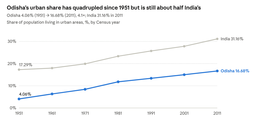
Odisha’s urban share has grown in every census since independence, with the fastest jump in the 1970s, when Rourkela, Bhubaneswar, the Hirakud–Burla–Sambalpur complex, Talcher–Angul and the mining towns of Keonjhar and Sundargarh expanded rapidly. But the gap with India has not closed: the national urban share has risen almost as fast, so Odisha has remained at roughly half the national level for six decades. Slow industrialisation outside a few pockets, a large rural agricultural and tribal population, and small, slow-growing district towns explain the lag.
Major Cities and Towns
Largest urban centres (Census 2011)
| Rank | City / urban agglomeration | District | Population (2011) | Main function |
|---|---|---|---|---|
| 1 | Bhubaneswar | Khordha | 8,81,988 | State capital; administration, IT, education, temple city |
| 2 | Cuttack | Cuttack | 6,58,986 | Old capital; trade, judiciary (Orissa High Court), commerce |
| 3 | Rourkela | Sundargarh | 5,52,970 | Steel city (Rourkela Steel Plant, 1959) |
| 4 | Berhampur (Brahmapur) | Ganjam | 3,55,823 | Commercial centre of south Odisha; silk |
| 5 | Sambalpur | Sambalpur | 3,35,761 | Gateway of western Odisha; Hirakud, handloom (Sambalpuri) |
| 6 | Puri | Puri | 2,01,026 | Pilgrimage (Jagannath Temple) and beach tourism |
| 7 | Balasore (Baleswar) | Balasore | 1,44,373 | Trade; DRDO missile test range at Chandipur |
| 8 | Baripada | Mayurbhanj | 1,16,874 | Former princely capital; administrative and tribal market town |
| 9 | Bhadrak | Bhadrak | 1,07,463 | Agricultural trade centre |
City profiles
- Bhubaneswar — one of independent India’s first planned capitals. After Cuttack’s congested site between the Mahanadi and Kathajodi rivers was found unsuitable for expansion, the new capital was founded in 1948 on the laterite upland west of the old temple town; the German architect-planner Otto Koenigsberger prepared its master plan on the neighbourhood-unit concept. Today it is the core of the Bhubaneswar–Cuttack–Puri–Paradip economic region, an IT and education hub (IIT, AIIMS, NISER, XIM University), and ranked first in the first round of India’s Smart Cities Mission (2016).
- Cuttack — the “Millennium City”, founded as a military camp (kataka) and capital from about the 12th century under the Ganga kings until 1948. It stands at the head of the Mahanadi delta, protected by stone embankments, and is famous for its silver filigree (tarakasi) and Bali Jatra.
- Rourkela — a classic industrial new town built around India’s first public-sector integrated steel plant with German collaboration (1959). It has a planned steel township and is a smart city (2017).
- Berhampur — the “Silk City” and the largest city of southern Odisha, a trading centre for the Ganjam–Gajapati region.
- Sambalpur — the historic centre of western Odisha on the Mahanadi, close to the Hirakud dam and Burla; known for Sambalpuri textiles and Samaleswari temple.
- Puri — one of India’s four dhams, with a linear temple-town plan along the Bada Danda (Grand Road) on which the Rath Yatra moves.
- Industrial and mining towns — Jharsuguda, Angul–Talcher (coal and aluminium), Paradip (port and refinery), Jajpur Road–Kalinganagar (steel), Joda–Barbil (iron ore), Damanjodi (bauxite–alumina) and Brajrajnagar–Belpahar are among the fastest-growing urban centres.
Smart and mission cities
Bhubaneswar (2016) and Rourkela (2017) were selected under the Smart Cities Mission. Nine cities — Bhubaneswar, Cuttack, Rourkela, Berhampur, Sambalpur, Puri, Balasore, Baripada and Bhadrak — were taken up under AMRUT for water supply, sewerage and green spaces.
Evolution, Functions and Regional Pattern
Historical evolution of settlements
- Early historic period — fortified cities such as Sisupalgarh near Bhubaneswar (a planned square city with gateways, c. 3rd century BCE) and Jaugada in Ganjam; port settlements like Palur and Manikapatna traded with Southeast Asia (the Bali Jatra tradition).
- Temple towns (7th–13th centuries) — Bhubaneswar (Ekamra Kshetra), Puri (Jagannath) and Konark grew around great temples under the Somavamshi and Eastern Ganga dynasties.
- Medieval fort and trading towns — Cuttack (capital from about 1135), Jajpur, Balasore and Pipili; Balasore became a European trading port in the 17th century.
- Princely-state capitals — Baripada, Keonjhar, Dhenkanal, Bolangir, Bhawanipatna, Jeypore, Paralakhemundi and Sambalpur were seats of the feudatory states that merged with Odisha in 1948–49.
- Post-independence planned towns — Bhubaneswar (capital), Rourkela (steel), Burla–Hirakud (dam), NALCO towns of Damanjodi and Angul, Paradip (port, 1966), and HAL Sunabeda (aircraft engines).
Functional classification of towns
| Function | Examples |
|---|---|
| Administrative | Bhubaneswar, district headquarters towns |
| Industrial | Rourkela, Jharsuguda, Angul, Kalinganagar, Choudwar, Rayagada (paper) |
| Mining | Joda, Barbil, Talcher, Brajrajnagar, Damanjodi, Koira |
| Port and fishing | Paradip, Gopalpur, Dhamra, Chandbali |
| Religious and tourist | Puri, Konark, Bhubaneswar, Jajpur, Kapilash |
| Commercial and market | Cuttack, Berhampur, Sambalpur, Bargarh, Bhadrak, Jeypore |
| Educational | Bhubaneswar, Cuttack, Berhampur, Burla (VSSUT, VIMSAR) |
| Defence and research | Chandipur (missile test range), Sunabeda (HAL), Charbatia (air base) |
Regional pattern of settlements
- Coastal plains — the highest density of both rural and urban settlement. Large compact villages, the state’s main urban corridor (Bhubaneswar–Cuttack–Puri), and a chain of district towns along NH-16 (Berhampur, Khordha, Cuttack, Jajpur Road, Bhadrak, Balasore).
- Northern Plateau — hamleted tribal villages in the hills, but a dense cluster of industrial and mining towns along the Brahmani and Baitarani valleys (Rourkela, Jharsuguda, Joda–Barbil, Keonjhar).
- Central tableland — the Mahanadi–Brahmani valleys with Angul–Talcher, Dhenkanal and Sambalpur; growing industrial towns on the coalfields.
- Western Odisha — large villages in the Hirakud command, hamleted villages in drought-prone uplands, and market towns (Bargarh, Balangir, Bhawanipatna, Nuapada).
- Eastern Ghats and southern hills — the sparsest settlement: dispersed tribal hamlets and a few towns (Koraput, Jeypore, Rayagada, Phulbani, Malkangiri, Paralakhemundi) at valley junctions and plateaus.
The result is a primate-free but coast-heavy urban hierarchy: no single city dominates the state, but the Bhubaneswar–Cuttack twin-city region is by far the largest node, and the interior relies on a thin network of small district towns.
Problems of Settlements and Government Initiatives
Problems of rural settlements
- Poor connectivity in hilly and forested areas — many tribal hamlets were reachable only on foot until recent rural road schemes (PMGSY, Biju Setu, Mukhya Mantri Sadak Yojana).
- Kutcha housing vulnerable to cyclones and floods, especially along the coast.
- Drinking water and sanitation gaps, particularly in western and southern Odisha; fluoride and iron contamination of groundwater in some districts.
- Natural hazards — cyclones (1999, Phailin 2013, Hudhud 2014, Titli 2018, Fani 2019, Dana 2024), floods in the delta, and coastal erosion that has swallowed villages such as Satabhaya in Kendrapara, whose residents were relocated to Bagapatia.
- Displacement from dams (Hirakud, Rengali, Upper Indravati) and mining and industrial projects.
Problems of urban settlements
- Slums — Census 2011 counted about 15.6 lakh slum dwellers in Odisha, roughly a fifth of the urban population; Bhubaneswar, Cuttack, Rourkela and Berhampur have the largest slum populations.
- Unplanned growth along highways and at city fringes, outpacing water supply, drainage and sewerage.
- Urban flooding and waterlogging in Cuttack and Bhubaneswar during heavy monsoon rain and cyclones.
- Traffic congestion and air pollution in the growing cities and industrial towns (Angul–Talcher, Jharsuguda, Rourkela).
- Weak finances of small ULBs and NACs.
Government initiatives
- JAGA Mission (Odisha Liveable Habitat Mission) — under the Odisha Land Rights to Slum Dwellers Act, 2017, the state surveyed slums with drones and granted land rights certificates to slum households, upgrading slums into liveable habitats with water, drains, roads and lighting. The mission received the World Habitat Award in 2023.
- PMAY (Urban and Gramin), Biju Pucca Ghar and the state’s Antyodaya Gruha Yojana for pucca houses.
- Drink from Tap mission (Sujal) supplying quality 24×7 piped water in Puri, Bhubaneswar and other towns; Jal Jeevan Mission and Basudha for rural water supply.
- Mo Bus (Capital Region Urban Transport) city bus service in Bhubaneswar–Cuttack–Puri, and plans for a Bhubaneswar metro.
- Urban Wage Employment Initiative (2020) and MUKTA — jobs for the urban poor through community works.
- Capital Region planning — the Bhubaneswar Development Authority’s comprehensive development plan and the proposed Bhubaneswar–Cuttack–Puri–Paradip economic region.
- Cyclone shelters — over 800 multipurpose cyclone and flood shelters along the coast, each managed by a village committee.
Conclusion
Odisha’s settlements reflect its geography: large, compact paddy villages and a growing urban corridor on the deltaic coast; hamleted villages and industrial towns on the mineral-rich Northern Plateau; and small, dispersed tribal hamlets in the forested Eastern Ghats. Although the state is still overwhelmingly rural, with only about one person in six living in towns, urbanisation is gathering pace — driven by Bhubaneswar’s growth, industrial and mining corridors, new census towns and the 2025 expansion of urban local bodies. The challenge ahead is to manage this transition so that new towns are planned, resilient to cyclones and floods, and inclusive of slum dwellers and migrants, while rural and tribal settlements gain the roads, housing, water and services they still lack.
Quick Facts
| Item | Fact |
|---|---|
| Urban population (2011) | 70.04 lakh (16.68%) |
| Rural population (2011) | 3.50 crore (83.32%) |
| Villages (2011) | 51,313 (47,539 inhabited) |
| Towns (2011) | 223 — 107 statutory, 116 census towns |
| Most urbanised district | Khordha (48.11%) |
| Least urbanised district | Boudh (4.65%) |
| Largest city | Bhubaneswar (8.82 lakh, 2011) |
| Municipal corporations | 6 — Bhubaneswar, Cuttack, Berhampur, Sambalpur, Rourkela, Puri (2025) |
| Smart cities | Bhubaneswar (2016), Rourkela (2017) |
| Planned capital | Bhubaneswar, founded 1948; master plan by Otto Koenigsberger |
| Slum land-rights programme | JAGA Mission (2017 Act); World Habitat Award 2023 |
Sources
- Urban Scenario — Housing & Urban Development Department, Government of Odisha
- Odisha’s Rural Roots & Urban Surge — The Truth One (Census urbanisation trend, villages, towns and district urbanisation)
- Odisha Population (Census 2011) — censusindia2011.com
- List of cities in Odisha by population — Wikipedia
- List of urban local bodies in Odisha — Wikipedia
- Odisha CM declares 7 municipalities and 16 NACs (Sept 2025) — Odisha Plus
- Odisha expands urban footprint with 24 new NACs (Dec 2025) — Devdiscourse
- Odisha — Wikipedia
- Census of India 2011: Primary Census Abstract and Town Directory, Odisha.
© Odisha Geography · Generated on November 7, 2026