
|
odishageography.com |
Climate
Pre-monsoon (Summer) Season in Odisha

The pre-monsoon season, popularly called summer or the hot season, lasts in Odisha from March to May, and often well into June until the south-west monsoon arrives. The India Meteorological Department (IMD) treats March, April and May as the pre-monsoon season.
It is the hottest and, in many ways, the most dangerous time of the year. Temperatures climb steadily from March, and in May the interior of western Odisha becomes one of the hottest regions in India, with afternoon temperatures regularly above 42°C. Along the coast the heat is less extreme but very humid.
The season is not only hot and dry. As the land heats, it also produces violent thunderstorms (kalbaisakhi) with lightning, hail and squalls, and the warm Bay of Bengal can give rise to powerful cyclones, such as Fani (2019). Heat waves, lightning and cyclones make this a key season for disaster management in Odisha.
Table of Contents
Why it gets so hot
- The sun moves north. After the spring equinox (about 21 March), the overhead sun moves into the northern hemisphere and passes directly over Odisha (between about 18°N and 22°N) in May. The days grow long and the sun shines almost vertically at noon.
- Clear, dry skies. Before the monsoon, skies are mostly cloudless, so the land receives intense sunshine and heats up quickly.
- A low over the land. As northern and central India heat up, a zone of low pressure develops over the subcontinent. Over Odisha, hot, dry north-westerly winds from central India (similar to the loo of northern India) blow across the western districts, pushing temperatures even higher.
- The sea’s influence. Along the coast, a sea breeze blows in from the cooler Bay of Bengal in the afternoon. It keeps maximum temperatures a few degrees lower than inland, but brings high humidity, which makes the heat feel oppressive.
- Distance from the sea. The farther inland a place is, the weaker the sea’s effect. That is why the western uplands (Titlagarh, Sambalpur, Jharsuguda, Bolangir) are far hotter than coastal towns.
These same conditions, intense heating of the land combined with moisture from the sea, also produce the season’s thunderstorms and set the stage for the arrival of the monsoon.
Temperature
Temperatures rise steadily through the season, peaking in May, the hottest month across almost all of Odisha.
Average May maximum temperatures (IMD normals, 1991–2020):
- Western Odisha is hottest: Titlagarh averages 42.4°C, and Sambalpur and Sundargarh about 41.2°C.
- The coast is milder: Bhubaneswar averages 37.7°C and Balasore 35.8°C, though the humidity makes it feel hotter.
- The southern highlands are a little cooler: Phulbani averages 38.4°C, and the Koraput plateau stays in the mid-30s.
Nights are warm too. By May, average minimum temperatures are about 25–27°C in Bhubaneswar, Sambalpur and Titlagarh, so there is little relief after sunset.
Record heat.
- Titlagarh in Bolangir district is often the hottest place in India in summer and has recorded up to 50.1°C, the highest temperature in its records, with record highs of 49.6°C in April and 49.8°C in May.
- Sambalpur has reached 49.0°C (June) and Sundargarh 47.6°C.
- Bhubaneswar‘s highest recorded temperature is 46.7°C, and it has reached 46.5°C in May.
In years when the monsoon is delayed, these extreme temperatures can continue into the first half of June.
May heat across Odisha
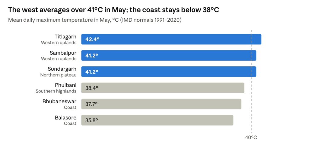
In an average May, the stations of western and northern Odisha cross 40°C every afternoon, while the coast stays a few degrees cooler thanks to the sea breeze. In the plains, IMD’s heat-wave warnings begin only when a station’s maximum reaches at least 40°C and is well above its normal, which is why heat waves are declared most often in the western districts.
Kalbaisakhi: thunderstorms, lightning and hail
The pre-monsoon is not completely dry. On many afternoons and evenings, especially in April and May, the intense heating of the land combined with moist air from the Bay of Bengal sets off violent thunderstorms. In Odisha and Bengal these storms are called kalbaisakhi (“the calamity of the month of Baisakh”), and in English nor’westers, because they usually approach from the north-west.
What a kalbaisakhi is like. A dark wall of cloud builds up quickly in the afternoon. It arrives with a sudden, strong squall that can blow at 60–100 km/h or more, followed by heavy rain, thunder and lightning, and sometimes hail. The storm usually passes within an hour, leaving the air much cooler.
Pre-monsoon rainfall. These storms give the pre-monsoon its rain. From March to May, Balasore receives about 250 mm and Bhubaneswar about 160 mm, while the drier western stations receive much less (Sambalpur about 60 mm, Titlagarh about 74 mm). The northern and coastal districts get the most, because they are closest to the moist air of the Bay of Bengal.
Benefits. The showers cool the air, help farmers prepare their fields and sow early crops, and help summer vegetables, jute and orchards in the northern districts.
Dangers.
- Lightning is Odisha’s deadliest natural hazard in terms of lives lost each year. Between 2019–20 and 2023–24, lightning killed 1,625 people in the state, about 290–370 a year, many of them farmers and labourers working in open fields. Odisha declared lightning a state-specific disaster in 2015.
- Squalls uproot trees, bring down power lines and damage thatched houses.
- Hail damages mango and cashew crops, vegetables and roofs.
Pre-monsoon cyclones
The Bay of Bengal has two cyclone seasons: April–June (pre-monsoon) and October–December (post-monsoon). In the pre-monsoon, the warm sea surface, often above 30°C, can feed very intense storms, which may strike Odisha in late April or May.
| Cyclone | Landfall | Intensity at landfall | Impact in Odisha |
|---|---|---|---|
| Fani (2019) | 3 May, near Puri | Extremely severe cyclonic storm; about 185 km/h (3-minute winds) | 64 deaths; over 1.2 million people evacuated; damage about ₹12,000 crore; Puri, Bhubaneswar and Khordha worst hit |
| Yaas (2021) | 26 May, near Dhamra–Bahanaga (Balasore–Bhadrak coast) | Very severe cyclonic storm; about 140 km/h | Storm surge and flooding along the northern coast; 2 deaths reported |
| Amphan (2020) | 20 May, West Bengal–Bangladesh coast | Super cyclone at peak over the bay | Heavy rain and wind in northern coastal districts as it passed offshore |
Fani was one of the strongest cyclones to hit Odisha in summer in many decades. The state’s large-scale evacuation, building on lessons learned after the 1999 Super Cyclone, was widely praised for keeping the death toll low despite the storm’s strength.
Heat waves
A heat wave is a spell of unusually high temperatures. In the plains, IMD declares one when a station’s maximum temperature reaches at least 40°C and is about 4.5°C or more above normal, or when it reaches 45°C regardless of the normal.
The 1998 disaster. In May 1998 a severe heat wave killed 2,042 people across Odisha, in both coastal and western districts, according to hospital reports. The scale of the tragedy changed how the state approaches heat.
Odisha’s heat action. Since 1998, Odisha has treated heat waves as a disaster “on the scale of a cyclone or flood”. Its heat action measures, prepared each year from late February, include:
- early hours for schools, colleges and offices, and early summer vacations in severe years;
- suspension of outdoor public works, such as MGNREGA work, and of some bus services in the hottest afternoon hours;
- drinking-water booths (jalachhatras) run by panchayats and volunteers;
- hospitals and health centres prepared with ORS, ice and cooling for heat-stroke patients;
- daily monitoring of IMD forecasts by state and district control rooms, and public awareness campaigns.
Heat-stroke deaths fell sharply after 1998, to 91 in 1999 and 41 in 2002, although severe summers still claim lives, especially among outdoor workers, the elderly and the poor.
Other impacts. Heat waves dry up ponds and wells, raise demand for electricity, increase forest fires in hilly districts, stress livestock and poultry, and reduce the productivity of outdoor workers.
Farming, water and daily life
Agriculture. Summer is a lean season for most farmers. Where canal or lift irrigation is available, farmers grow summer (dalua) paddy, vegetables, groundnut, sesame and green gram. Elsewhere fields lie fallow, and farmers plough them after the first pre-monsoon showers to prepare for the kharif season. Mango, jackfruit and cashew ripen in this season, and the collection of kendu leaves and mahua flowers provides important income in forest areas.
Water. The dry heat lowers rivers, reservoirs and groundwater. Small streams in western Odisha dry up completely, and many villages and towns face drinking-water shortages until the monsoon arrives.
Daily life. People adapt by working early and resting during the afternoon heat. Cooling drinks such as pana (a sweet drink of bel, curd and jaggery), pakhala (fermented water rice) and buttermilk are part of summer life in Odisha.
Festivals of the season.
- Pana Sankranti (Maha Vishuva Sankranti), around 14 April, the Odia New Year, marked by offering pana to neighbours and visitors.
- Chandan Yatra (April–May), when representative images of the Jagannath Temple deities are taken out on boats on the Narendra tank in Puri, and sandalwood paste is used to cool them in the hottest weeks.
- Akshaya Tritiya, which marks the start of chariot-building for the Rath Yatra and of sowing in many villages.
- Raja Parba (mid-June), at the end of the hot season, celebrating the earth’s fertility as the monsoon arrives.
Regional variations
| Region | Examples | Summer character | Main hazards |
|---|---|---|---|
| Western uplands | Titlagarh, Bolangir, Sambalpur, Jharsuguda, Bargarh | Hottest and driest; May afternoons over 41–42°C; hot, dry winds | Severe heat waves, water scarcity, forest fires |
| Northern plateau | Sundargarh, Keonjhar, Mayurbhanj | Very hot days; frequent afternoon thunderstorms in April–May | Heat, lightning, hail |
| Coastal plains | Balasore, Bhadrak, Cuttack, Puri, Bhubaneswar, Ganjam | Hot and very humid; sea breeze limits maximum to about 35–38°C | Humid heat stress, kalbaisakhi squalls, cyclones |
| Southern highlands | Koraput, Kandhamal, Rayagada | Warm days but cooler than the plains; pleasant nights at height | Lightning, forest fires, local drinking-water shortage |
Temperatures are approximate and based on station normals; individual places and years vary.
Summary
Odisha’s pre-monsoon or summer season, from March to May (often into June), is the hottest time of the year. The overhead sun, clear skies and hot winds from central India drive May temperatures above 41°C in the western districts, while the coast stays a little cooler but very humid. The season also brings kalbaisakhi thunderstorms, deadly lightning and, in some years, powerful cyclones from the Bay of Bengal. After the deadly heat wave of 1998, Odisha became a pioneer in heat-action planning, and the season remains central to the state’s disaster management.
Key facts at a glance
- Season: March–May (IMD pre-monsoon), often into early June
- Hottest month: May
- Average May maximum: Titlagarh 42.4°C; Sambalpur and Sundargarh 41.2°C; Bhubaneswar 37.7°C; Balasore 35.8°C
- Highest recorded: Titlagarh 50.1°C; Sambalpur 49.0°C; Bhubaneswar 46.7°C
- Pre-monsoon rain (Mar–May): about 60 mm in the west to 250 mm in the north-east coast
- Storms: kalbaisakhi (nor’westers) in April–May
- Lightning: 1,625 deaths in five years (2019–20 to 2023–24); a state-specific disaster since 2015
- Major cyclones: Fani (May 2019), Yaas (May 2021)
- Heat wave of 1998: 2,042 deaths; led to Odisha’s heat action plan
Notes on the figures
- Station averages and records are IMD figures as given on Wikipedia; record periods differ between stations.
- The heat-wave criteria are IMD’s general definitions for the plains.
- The 1998 death toll is from hospital reports cited by Business Standard.
- Details of kalbaisakhi wind speeds, crops and festivals are from general knowledge and should be checked before citing.
Sources
- Titlagarh – Wikipedia (IMD climate table)
- Sambalpur – Wikipedia (IMD climate table)
- Sundargarh – Wikipedia (IMD climate table)
- Bhubaneswar – Wikipedia (IMD climate table)
- Balasore – Wikipedia (IMD climate table)
- Phulbani – Wikipedia (IMD climate table)
- Cyclone Fani – Wikipedia
- Cyclone Yaas – Wikipedia
- How to fight the heat wave the Odisha way – Business Standard
- Lightning strikes claimed 1,625 lives in five years – Orissa Post
- Lightning claims more lives than any other calamity – Down To Earth
© Odisha Geography · Generated on November 8, 2026